Dr Guy Schumann, CEO and Principal Scientist at RSS-Hydro Sarl-S, proposes the development of innovative ML-based application software solutions that can overcome many current EO limitations to offer a better global flood disaster response.
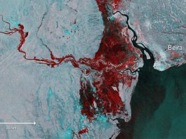
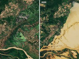
Remote sensing, and particularly Earth Observation (EO) from space, offers many advantages over traditional ground-based monitoring methods or computer models: large spatial coverage; frequent revisit times; abundant open access data, and long historic image archives, particularly in the case of optical imagery. Typically, during floods, Synthetic Aperture Radar (SAR) sensors are preferred since these can penetrate cloud cover, are largely independent of weather, and can operate during both day and night. In fact, EO is now regarded by most data providers and decision-makers as almost indispensable for many applications, such as cartography, agriculture, and disaster management.
Nevertheless, EO still has some serious limitations when used in flood mapping applications, such as assisting flood disaster response efforts or (re)insurance operations. In fact, national and international disaster response organisations operating at both national and global level, such as the UN WFP (World Food Programme), are often lacking actionable, high-resolution and accurate geospatial information to quickly use and act upon.
State of the art may not be enough
A closer look at two of the major end-user segments reveals three main challenges which need to be addressed in a timely manner in order to increase the value and, consequently, the uptake of EO in end-user operations.
The first challenge is that persistent cloud cover during floods seriously limits the use of optical images, which also suffer from low spatial and temporal resolutions, something that has not yet been solved by traditional EO-based flood mapping algorithms. The second challenge is that SAR has much shorter historic archives than optical imagery, it is difficult to interpret, and it has its own limitations, particularly in urban areas. Last but not least, the third big challenge is that the processing is often slow and with long latency from image acquisition to flood map delivery – the well-known latency issue.
At present, there is no flood mapping application available on the market that can overcome the major limitations of optical EO imagery during floods while efficiently scaling between optical, SAR, and even drone images, with drones becoming an ever more popular and powerful means of acquiring timely, high-accuracy, and high-resolution data for many applications including disaster response operations.
More innovative solutions are needed
Earth Observation can offer an inviting solution but the spatial resolution of free EO imagery is often too coarse in areas where people and assets at risk are located and, although the orbital repeat cycle is constantly improving with more satellites being put into space, the typical temporal resolution is not high enough for applications requiring very timely actionable information. This is why several big national and international organisations, such as the UN WFP, have started employing drones and are looking into processing drone data with Machine Learning (ML) algorithms for mapping the extent of disasters, such as floods, at high-resolution and with minimal delay.
However, we argue that not using all available satellite data efficiently or discarding entire sensor types because of some (current) limitations will, without a doubt, be detrimental to effective flood disaster response assistance at global level.
In response to the popular demand of drones, Artificial Intelligence/Machine Learning (AI/ML), and EO data within the disaster response community, we propose to develop innovative ML-based application software solutions that can efficiently scale between satellite imagery and drone data, thereby overcoming many of the current EO limitations to offer a better flood disaster response. For instance, if developed, such novel applications could efficiently reconstruct flooded areas under partial cloud cover in optical satellite images.
Disaster response agencies at the regional, national, and international levels are keen to utilise the proliferation of open satellite data from ESA, NASA, and other space agencies, for flood mapping during emergencies. Also, in the insurance and re-insurance markets, stakeholders are interested in EO data to map the flood hazard of an event and on an historical basis to understand the exposure risk and the changing nature of it. Other end-user segment customers, in addition to the humanitarian response and (re)insurance sectors, are also interested in innovative remote sensing solutions to address their needs.
For Europe and beyond, future EO-based and ML-powered apps would considerably add to the competences of the existing free Copernicus emergency management services and beyond. It is clear that in the intersection of these two fields (EO technologies and AI/ML application tools), there is plenty of room for innovation, and this intersection has the potential to put many at the forefront of EO-enabled innovative solutions in the future, such as a much more effective disaster response.
Please note, this article will also appear in the fifth edition of our quarterly publication.