Researchers from the University of Illinois Urbana-Champaign have developed a way that a spacecraft can use pulsar star signals to navigate in space.
The remnants of a collapsed neutron star, called a pulsar, are magnetically charged and can spin anywhere from one rotation per second to hundreds of rotations per second. These celestial bodies, each 12 to 15 miles in diameter, generate light within the x-ray wavelength spectrum. Researchers from the University of Illinois’ Urbana-Champaign have developed a novel way a spacecraft can utilise signals from multiple pulsars to navigate in deep space.
Pulsar stars
“We can use star trackers to determine the direction that a spacecraft is pointing, but to learn the precise location of the spacecraft, we rely on radio signals sent between the spacecraft and the Earth. This can take a lot of time and requires the use of an oversubscribed infrastructure, like NASA’s Deep Space Network,” explained Zach Putnam, Professor in the Department of Aerospace Engineering at Illinois University.

“Using x-ray navigation eliminates those two factors, that until now, required an initial estimated position of the spacecraft as a starting point. This research presents a system that finds candidates for possible spacecraft locations without prior information, so that the spacecraft can navigate autonomously.
“Also, our ground communication systems for deep space missions are overloaded right now. This system would give spacecraft autonomy and reduce the dependency on the ground. X-ray pulsar navigation gets us around that and allows us to determine where we are, without calling.”
Electromagnetic radiation emissions
Because our atmosphere filters out all the x-ray emissions, you would have to be in space to observe them. The pulsars emit electromagnetic radiation that looks like pulses, because scientists can measure the peak in the x-ray signals every time the pulsar spins around and points toward Earth — like a ray of light cast from the beacon on a lighthouse.
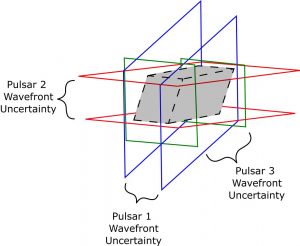
Intersection of banded regions of three pulsars in 3D.
“Each pulsar has its own characteristic signal, like a fingerprint,” Putnam added. “We have records of the x-rays over time from the 2,000 or so pulsars and how they have changed over time.”
Much like the Global Positioning System, location can be determined from the intersection of three signals.
“The issue with pulsars is that they spin so fast that the signal repeats itself a lot,” Putnam expressed. “By comparison, GPS repeats every two weeks. With pulsars, while there are an infinite number of possible spacecraft locations, we know how far apart these candidate locations are from each other.
“We are looking at determining spacecraft position within domains that have diameters on the order of multiple astronomical units, like the size of the orbit of Jupiter. The challenge we are trying to address is, how do we intelligently observe pulsars and fully determine all possible spacecraft locations in a domain without using an excessive amount of computing resources.”
Locating space craft positions
The algorithm developed by graduate student Kevin Lohan combines observations from numerous pulsars to determine all the possible positions of the spacecraft. The algorithm processes all the candidate intersections in two or three dimensions.
“We used the algorithm to study which pulsars we should observe to reduce the number of candidate spacecraft locations within a given domain,” concluded Putnam.
The results revealed that observing sets of pulsars with longer periods and small angular separations could significantly reduce the number of candidate solutions within a given domain.