University of Washington research suggests that using signals from Earth’s ionosphere could effectively optimise tsunami warning systems.
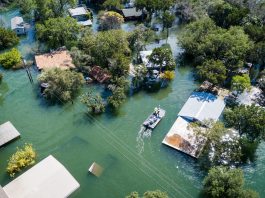
The researchers analysed the tsunami caused by the Hunga Tonga-Hunga Ha’apai volcanic eruption in the South Pacific earlier this year – the largest recorded by modern equipment. The resulting tsunami caused a range of unexpected distant effects and was first predicted as only a regional hazard. However, the wave killed at least three people on the island of Tonga, travelling as far as Peru, where a further three people drowned, highlighting how accurate tsunami warning systems are essential.
The study, ‘Spectral Characteristics of Ionospheric Disturbances Over the Southwestern Pacific From the 15 January 2022 Tonga Eruption and Tsunami,’ explores how evidence from the ionosphere explains why the tsunami grew larger and travelled faster than tsunami forecasts predicted.
Jessica Ghent, the lead author and a University of Washington doctoral student in Earth and space sciences, explained: “This was the most powerful volcanic eruption since the 1883 eruption of Krakatau, and a lot of aspects of it were unexpected. We used a new monitoring technique to understand what happened here and learn how we could monitor future natural hazards.”
Current tsunami warning systems are inadequate
Due to tsunamis being an extremely rare natural disaster, current tsunami warning systems are far from optimised and rely on a limited number of tide gauges and ocean sensors. In order to advance forecasting, the study focused on using GPS signals travelling through the upper atmosphere to track events on the ground.
For example, a large earthquake or volcanic eruption generates pressure waves in the atmosphere. As they pass through the zone known as the ionosphere – around 50 to 400 miles altitude and where electrons and ions float freely – particles are disturbed. GPS satellites sending coordinates down to Earth transmit a slightly modified radio signal that monitors the disturbance.
Brendan Crowell, co-author and a University of Washington research scientist in Earth and space sciences, said: “Other groups have been looking at the ionosphere to monitor tsunamis. We are interested in applying it for volcanology. This Tonga eruption kicked our research into overdrive. There was a big volcanic eruption and a tsunami — normally, you’d study one or the other.”
Mapping tsunamis with the ionosphere
For the investigation, the team utilised 818 ground stations in the Global Navigation Satellite System around the South Pacific to analyse the atmospheric disturbance in the hours after the eruption. Results showed that the sonic boom from the volcanic explosion made the tsunami larger and faster, as the ocean wave was enhanced by the atmospheric pressure wave created by the eruption. The initial tsunami forecasts did not account for this boost, explaining why it was underestimated.
Ghent said: “Tsunamis typically can travel in the open ocean at 220 meters per second or 500 miles per hour. Based on our data, this tsunami wave was moving at 310 meters per second or 700 miles per hour.”
The researchers subsequently separated the different aspects of the eruption, such as the acoustic sound wave, the ocean wave, and other types of pressure waves, to check their accuracy against ground-based observations.
Ghent explained: “The separation of these signals, from the acoustic sound wave to the tsunami, was what we had set out to find. “From a hazards-monitoring perspective, it validates our hope for what we can use the ionosphere for. This unusual event gives us confidence that we might someday use the ionosphere to monitor hazards in real-time.”
The potential new system for improving volcano and tsunami warning systems has a range of advantages due to ground-based monitoring being difficult in the Pacific Northwest and other areas. This is because sensors must be maintained and repaired, snow and ice can inhibit signals, accessing the monitoring stations can be difficult, and animals can eat through the cables of ground instruments.