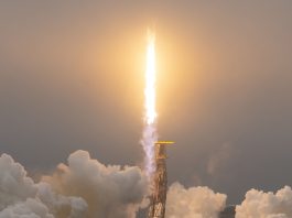
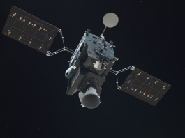
A landmark moment in European weather monitoring has arrived as Meteosat-12, the first imaging satellite in the Meteosat Third Generation (MTG) programme, officially assumes responsibility for Europe’s primary geostationary satellite data service.
Now stationed above the equator at 0° longitude, directly over the Gulf of Guinea, this advanced satellite is poised to transform how meteorologists observe and forecast weather across Europe, Africa, and surrounding oceans.
Replacing Meteosat-10 in its prime operational role, Meteosat-12 marks the beginning of a new chapter in EUMETSAT’s mission to enhance global weather monitoring, forecasting accuracy, and climate analysis capabilities.
A leap forward in Earth observation technology
Launched on 13 December 2022, Meteosat-12 orbits Earth at an altitude of approximately 36,000 kilometres.
It scans the entire Earth’s disc every 10 minutes, offering meteorologists more frequent and sharper imagery than ever before.
At the heart of its innovation are two sophisticated instruments: the Flexible Combined Imager (FCI) and Europe’s first space-based Lightning Imager (LI).
The FCI delivers data in twice the number of spectral channels compared to its predecessor, capturing weather systems in greater detail and at higher resolution.
This capability is critical for detecting rapidly forming weather phenomena such as storms, fog, and convective cloud development.
Meanwhile, the LI tracks lightning activity across Europe and Africa in both daylight and darkness, offering a vital new tool for assessing storm intensity and risk.
Strengthening forecasting in an age of extreme weather
As the effects of climate change intensify, severe weather events are becoming more frequent and more destructive.
Meteosat-12 is arriving at a crucial time. With its advanced instruments and faster data delivery, the satellite significantly enhances Europe’s ability to issue early warnings and respond to weather-related emergencies.
The MTG system represents a generational leap in satellite weather monitoring. It supports a broad range of critical services – from improving storm warnings and air traffic safety to supporting wildfire response and tracking air quality hazards.
With the future addition of sounder satellites like MTG-S1, expected to launch in 2025, forecasters will gain access to vertical profiles of atmospheric temperature and humidity from geostationary orbit – a first for Europe.
This comprehensive approach will allow meteorologists to observe the full lifecycle of storms, from the earliest atmospheric signals to lightning strikes, enhancing both short-term forecasting and long-term climate modelling.
The MTG constellation: A cohesive network for climate resilience
Meteosat-12 is the first of six satellites planned in the MTG constellation, which will include four imagers and two sounders.
Together, they will form a resilient, interconnected system that supports continuous weather and climate monitoring into the 2040s.
While Meteosat-12 now delivers the core geostationary service, it is part of a larger coordinated constellation. Meteosat-10 transitions to a backup role, ready to support or resume operations if needed.
Meteosat-11 continues to provide rapid scans every five minutes over Europe and North Africa, while Meteosat-9 remains stationed over the Indian Ocean, supplying essential data to regions vulnerable to cyclones and monsoons.
This multi-satellite strategy ensures redundancy, stability, and uninterrupted service, safeguarding Europe’s meteorological infrastructure in the face of rising global climate volatility.
Why advancing European climate monitoring matters
Beyond immediate forecasting benefits, the MTG programme plays a critical role in advancing European climate monitoring.
Long-term satellite data is indispensable for understanding climate trends, assessing the frequency and intensity of extreme events, and informing national and international policy responses.
By capturing more precise, continuous, and wide-ranging environmental data, Meteosat-12 strengthens Europe’s ability to track atmospheric changes, monitor the health of ecosystems, and measure the impacts of climate initiatives.
With rising demand for climate intelligence in sectors like agriculture, energy, and urban planning, improved weather monitoring contributes not only to public safety but also to economic resilience and sustainable development.
Looking ahead
The successful operational handover from Meteosat-10 to Meteosat-12 is a milestone achieved through years of collaborative effort across EUMETSAT, its member states, and industry partners.
As more satellites in the MTG series are launched in the coming years, the full constellation will provide an unprecedented window into the dynamics of our atmosphere.
Weather monitoring has entered a bold new era – one where science, technology, and international cooperation unite to meet the challenges of a changing world.