Dr Ylona van Dinther, an Associate Professor at Utrecht University, has pioneered research into earthquakes and tectonic movements for many years. Her latest venture, the ERC Consolidator project RESET, now aims to significantly improve earthquake forecasts of where, how, and maybe even when they will occur.
As history has demonstrated, large earthquakes can be a significant global threat with devastating consequences. However, predicting the location, size and timing of earthquakes is thought to be impossible. Now, thanks to new discoveries and advances in technology, researchers are making major breakthroughs towards earthquake forecasting.
Dr Ylona van Dinther, Associate Professor in earthquake physics and tectonics at Utrecht University, has studied earthquakes and plate tectonics for many years. Her research interests span the fields of tectonics; seismology; tectonophysics; earthquake, fault and rock mechanics; mantle dynamics; and structural geology.
The first major breakthrough in Dr van Dinther’s research came when she pioneered the bridging of time scales from tectonic time scales (millions of years) towards earthquake time scales (milliseconds) in numerical models, earning her several awards. She then broadened her expertise by pioneering the application of ensemble-based data assimilation techniques from weather forecasting to earthquake forecasting with physics-based models.
Most recently, Dr van Dinther has been granted funding from the European Research Council (ERC) for a new project designed to better forecast earthquakes and understand surface motions. The RESET (mega-thRust Earthquake SystEm Theory) project will capitalise on Dr van Dinther’s previous achievements and expertise to drastically improve inferences of earthquake locations, sizes and – to a limited extent – even timing.
To find out more about her research so far and how this will transfer to the new RESET project, The Innovation Platform spoke to Dr van Dinther.
What are the main areas of focus within your work?
I work across several disciplines related to the field of tectonophysics – the physics of plate tectonics.
One of my main research areas is earthquakes and understanding where, when, how and why they happen. I study natural seismicity – mainly focusing on the very large earthquakes such as the ones in Sumatra, Japan, and Chile –, as well as small, induced earthquakes caused by human interventions in the first few kilometres of the Earth.
My work on human-induced earthquakes mainly focuses on the gas field in Groningen – a province in the northeast of the Netherlands. We used to extract significant amounts of natural gas from there. However, as earthquakes continued to increase in quantity and magnitude and became too much for residents, all gas extraction activities were ceased. In the last decade, unprecedented amounts of data have been collected, making this a world-class natural laboratory to understand the physics of earthquakes. We need learnings from this exceptional case study to assist in providing sustainable solutions for our society’s energy transition, which requires our Earth’s storage and heat capacity.
I also study plate tectonics – the movement of large, rigid plates that cover the first 100km of the Earth. I use my research in this area to inform my understanding of earthquakes and things like how mountains form, mainly using numerical models to do so. I also work on data assimilation – integrating these numerical models robustly with observations.
What are your main priorities and objectives at present?
In the last few years, my work has mainly focused on the human-induced earthquakes in Groningen. From a societal perspective, this was a very urgent matter. I felt compelled to complement the answer to the most important question, “how large can earthquakes get?”, with information from physics.
My main goals are fundamental in terms of earthquake physics understanding. My team’s work aims to determine where, when and why earthquakes will initiate and where they will stop. If you know where earthquakes start and stop, you can gain a good idea of the size of the earthquake. We try to use that information gathered from physics-based models and observations to inform hazard assessment, which people and policymakers can use. We are also trying to transfer our learnings from gas extraction to more sustainable activity that can benefit from the subsurface, such as geothermal energy and hydrogen and carbon dioxide storage.
Whilst induced seismicity has been my main priority for the last five years, I have also related this to some data assimilation work. Data assimilation is essentially weather forecasting – applying the techniques used for weather forecasting to see if, and how, they can work for earthquake forecasting.
I kept working a little on natural seismicity and this is something that I will be working on a lot more with the RESET project. So far, I have mainly been doing the recruitment and organisation for the project. Suffice to say that a promising team is being gathered.
Alongside my research work, I also teach. Currently, I am setting up two new BSc courses – Modelling of Earth’s Systems and Earth’s Heat, Dynamics and Hazards.
What have been the key achievements in your work so far?
In my MSc at Utrecht University, I envisioned we could gain much understanding if we could use numerical models simulating plate tectonics over millions of years as well for simulating earthquakes on milli-second time scales. I developed that bridging of time scales, models, and communities during my PhD at ETH Zürich. When I began my PhD, most people thought this was impossible. However, once I showed that it was indeed possible, a lot of opportunities opened up. Following this achievement, I was offered a Senior Scientist and Lecturer position at ETH Zürich. Here, I led a group of six PhD students and stayed for five years to develop that direction more with PhD students.
Whilst I was expanding the field of numerical seismo-tectonics, I also took on the challenge of working with ensemble-based data assimilation. In a proof-of-concept study, we wanted to test if we could use weather forecasting for earthquake forecasting. Again, people thought this wouldn’t be possible because we have much fewer data for the interior of the Earth than we do for the atmosphere. However, we found that we don’t need that much data. There is strong potential for using data assimilation for earthquake forecasting, but there are still many challenges to overcome. It is a big task and is not easy to do, but I will continue to work on this within the RESET project as well.
Finally, last year my group explained why earthquakes can occur in rocks previously considered not able to sustain earthquake initiation, and what implications that has for still being able to use the subsurface. Together with my colleagues, we are also the first to provide physics-based information on the maximum sizes of human-induced earthquakes as input for operational seismic hazard assessment.
Can you tell us more about what the RESET project is and how your previous work will complement this?
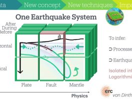
The RESET project mainly builds on my first two major achievements. The first was the bridging of time scales from plate tectonics towards earthquakes. This provided a unifying system perspective where, rather than seeing things as different fields and different spatial components that are not related, we could see how they are related. It was really exciting, because we predicted that certain observations should be happening at the Earth’s surface that we didn’t observe yet. Soon after, those vertical motions of the Earth’s surface were measured more accurately and we could see that there might be truth in our predictions. This information will be critical to make an image or map of where faults – large fractures in the Earth’s crust – are, and will be, moving. Scientists have done that over the last one to two decades, but only with horizontal motions. These vertical motions tell us much more about where, and at what depth, faults are stuck. With that, we can better image the location of future earthquakes.
We do, however, need to do a lot of work to be able to carry out these calculations fast. We need very fast numerical models and a new imaging framework to be able to account for the vertical motions of the Earth’s surface. RESET focuses on developing this new framework and running that forward and backward to see what motions and processes happen before, during, and after large earthquakes.
Scientists traditionally carry out this imaging and analysis either before, during, or after an earthquake. By integrating observations before, during, or after earthquakes, the team will have a lot more data to better image fault motions, estimate parameters, and understand Earth processes. Transforming our static into a system-concept will allow us to prepare Earth science’s most foundational theory of plate tectonics for new discoveries.
This will build to the first probabilistic seismic hazard assessment that is based on first physical principles. That will hopefully give us a good indication of where large earthquakes will occur. The latest satellite observations suggest that we may receive indications that large earthquakes could be coming. If that is really the case, we might even be able to say something about the timing of earthquakes. Earthquake prediction is impossible – it’s too hard, has too few observations, and is too nonlinear. However, we can say something probabilistically, using statistics to estimate the chances of certain occurrences. If we can integrate all data and system-level physics, we might be able to make an important step forward in probabilistic forecasting of earthquakes.
What are your plans for the near and long-term future?
To reach our five-year goal, we first need to build these earthquake system models in the next couple of years. We’ve done that in 2D in C and with simple usage of multiple computers at the same time to make it fast, but we need to do that much faster. We’ll use new high-performance computing techniques that rely on graphical processing units (GPUs) and use solvers to calculate the solution without building the whole matrix.

We build on what some colleagues have already done for glacial movements and other plate tectonic processes. We will add in the physics that we need for earthquakes and adapt the framework for our applications. This research will focus on subduction zones, where the plates are colliding with each other. The heaviest part goes down into the mantle, deep into the Earth. The heaviest part is always the ocean, and it is the ocean floor that will go down. It’s these movements at this interface between two plates that we want to image. These are the really large earthquakes that only happen once every few hundred years. However, when they do, they shake the entire region and the whole planet with them. After the 2011 Tohoku earthquake in Japan that caused the nuclear disaster, the whole world was in shock. It’s rare but, actually, almost 40% of the world’s population lives in areas that can be affected by these large earthquakes. These earthquakes also tend to generate tsunamis, that affect many coastlines where many people live.
Please note, this article will also appear in the 22nd edition of our quarterly publication.