SDGs-EYES turns satellite data into smart tools to boost Europe’s progress on sustainability goals.
The SDG-s EYES project (Sustainable Development Goals – Enhanced monitoring through the family of Copernicus services) is a Horizon Europe research and innovation action (RIA) designed to strengthen Europe’s capacity to monitor SDGs using Copernicus data. By developing a portfolio of decision-support tools for SDG indicators monitoring, SDGs-EYES aligns with the EU Green Deal priorities and promotes an inter-sectoral approach to sustainability monitoring, directly supporting climate-action objectives with satellite-driven solutions.
Seven services have been developed under the SDGs-EYES umbrella to demonstrate how its methodology and tools can enhance reporting of SDG 13 (Climate Action), SDG 14 (Life below Water) and SDG 15 (Life on Land). The SDGs-EYEs services have been co-designed with national statistical offices, environmental agencies, and forest managers, thus bringing researchers and community experts together with different stakeholder communities.
SDGs-EYES operates within the framework established by the United Nations and national statistical systems for SDG monitoring.
The vision in action
To translate its overarching ambition into tangible outcomes, SDGs-EYES focuses on interlinked objectives:
- Enhancing access and usability of Earth observation data
SDGs-EYES has built a scientific and technological framework to generate robust and accurate data to monitor indicators. By aggregating and processing data from Copernicus’s six core services, along with space-based and in situ sources, the project makes Earth observation (EO) data more accessible, usable and actionable. - Improving the quality of SDG indicators
The project demonstrates Copernicus-enhanced measurement for seven indicators across three SDG goals (SDGs 13, 14 and 15). - Building stakeholder capacity for societal impact
To maximise relevance and usability, SDGs-EYES delivers service-oriented data products co-designed with end-users, including public authorities, researchers, and environmental agencies. This collaborative approach ensures the tools are fit for purpose in real-world decision-making and reporting contexts.
These objectives converge to realise the project’s overarching ambition: to develop user-friendly, precise and efficient tools that enhance the monitoring, reporting and use of SDG indicators across Europe.
Building the blocks: The SDGs-EYES framework
SDGs-EYES brought research and industry experts together with stakeholders from various communities to co-develop a scientific, technological and user engagement framework for monitoring SDGs indicators.
SDGs-EYES methods and tools have been designed to be:
- User-driven – over a series of workshops and consultations, end-users provided feedback, thus ensuring the maximisation of their uptake and impact in the methodology design.
- Science-driven – bringing together already existing data and enriching them using other sources from EO and Copernicus leads to a sound scientific and technological framework to enhance indicators monitoring and reporting.
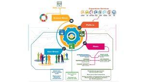
The structure of the SDGs-EYES project is provided in Fig. 1, and it can be summarised in the following main components:
- Data integration platform – A platform for the aggregation and processing of multiple EO data sources, including satellite, in situ, numerical models and data analytics.
- Pilots demonstration – Five pilot projects have been implemented to demonstrate, evaluate, and assess the services developed in real-world contexts.
The platform
The platform is cloud-based, cost-effective, and features an intuitive interface, making it accessible even to smaller administrations. It offers a faster and potentially more reliable alternative to traditional national inventories, which typically report SDGs indicators annually.
The pilots
SDGs-EYES solutions are demonstrated through four EU and one non-EU pilot areas. The location of the pilots is shown in Fig. 2.
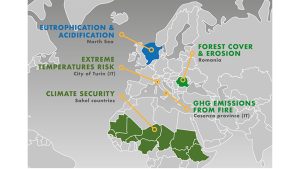
Pilot 1 – Greenhouse gasses (GHGs) emissions from forest fires
This pilot advances SDG monitoring, reporting, and accounting for GHGs emissions resulting from forest fires. Leveraging Copernicus burnt-area, biomass and scorch-height products – alongside in situ calibration data – it produces high-precision emission maps to support SDG 13 reporting. It highlights the importance of closer collaboration between research institutions, national statistical offices, forestry experts, private companies, and policymakers to improve GHGs emissions tracking across the EU.
Pilot 2 – Extreme temperature risks in urban areas
Focusing on the urban heat-health nexus, this pilot develops a Copernicus-based tool that maps climate hazards alongside demographic, socio-economic, health, and built environment data. The integrated risk assessment informs planning and response strategies for extreme temperature events in urban areas, directly underpinning SDG 13 resilience efforts.
Pilot 3 – Eutrophication and acidification in the North Sea
Focusing on marine SDGs, this pilot exploits Copernicus Marine Service datasets – together with satellite, in situ and model outputs – to generate high-resolution maps of seawater acidity and nutrient-driven eutrophication. The resulting indicators enhance SDG 14 monitoring, guiding policy on coastal eutrophication, acidification hotspots and sustainable marine resource management.
Pilot 4 – Forest cover and erosion
Employing time-series Sentinel imagery and machine-learning classifiers, this pilot quantifies forest cover dynamics and pinpoints soil-erosion risk zones. By automating the detection of deforestation, degradation and erosion hotspots, it strengthens SDG 15 indicators on terrestrial ecosystem health and land-use sustainability.
Pilot 5 – Climate security in the Sahel
This pilot focuses on assessing disaster impacts, including affected buildings and communities in the Sahel region (part of sub-Saharan Africa), to support climate security and disaster resilience. These datasets feed SDG 13.1.1 (‘affected persons per 100,000’) and inform resilience and security policies for vulnerable Sahelian populations.
Actionable insights: the SDGs-EYES service framework
The SDGs-EYES project has developed a suite of advanced, Earth observation-driven services, each designed to enhance the monitoring and reporting of specific SDG indicators across climate, marine, and terrestrial domains.
- Green-house gas emissions from forest fires (EFF)
This service automates near-real-time estimation of GHGs emissions (CO₂, CH₄ and others) from forest fires. It uses Copernicus burnt-area, biomass, and scorch-height products, calibrated with in situ data, to produce high-resolution emission maps. This advances national reporting under IPCC and UNFCCC¹ Guidelines, enhancing EU-wide data compiled by the European Environment Agency.
Target indicator: EU SDG indicator 13.21 ‘Net greenhouse gas emissions of the land use, land use change and forestry (LULUCF) sector’ and UN indicator 13.2.2 ‘Total greenhouse gas emissions per year’.
2. Heat-health nexus risk (HHR) in urban areas
This service integrates climate hazard metrics (temperature, humidity, precipitation), demographic, socio-economic, health, and built-environment data into a Copernicus-based tool. The result is high-resolution risk maps that support urban resilience and health-focused adaptation strategies.
Target indicator: it advances the old EU SDG indicator ‘mean near-surface temperature deviation’ by developing a comprehensive heat-health risk indicator.
3. Affected Buildings and People (ABP)
This innovative EO-based service quantifies disaster impacts, such as damaged structures and affected populations, following floods or extreme events in the Sahel. It fills a crucial data gap, supporting resilience policy in fragile regions by translating EO data into humanitarian-relevant indicators.
Target Indicator: UN 13.1.1 ‘Number of deaths, missing persons, directly affected persons per 100,000’.
4. Sea Surface Acidity (SSA)
Using Copernicus Marine Service data along with satellite and in situ systems, this indicator tracks pH levels in the North Sea. It enables monitoring of ocean acidification trends, which is critical for marine ecosystem conservation.
Target indicator: EU definition ‘Global mean seawater surface acidity’, reflects the UN indicator 14.3.1 ‘Average marine acidity (pH) measured at agreed suite of representative sampling stations’.
5. Marine waters eutrophication
This service maps coastal eutrophic zones within the EU’s Exclusive Economic Zone (EEZ) using remote sensing and oceanographic models. Outputs include the total area (km²) and proportion (%) of eutrophic waters to inform marine ecosystem health strategies.
Target indicators: based on the EU definition ‘Marine waters affected by eutrophication’, also reflects the UN indicator 14.1.1(a) ‘Index of coastal eutrophication’.
6. Forest cover change (FCC)
By leveraging high-resolution Sentinel imagery and change-detection algorithms, this service identifies not only forest extent but also alterations in forest cover, including deforestation, afforestation, and degradation hotspots.
Target indicator: recalling the EU definition ‘Share of forest area’, is also UN indicator 15.1.1 ‘Forest area as a proportion of total land area’.
7. Soil erosion by water (SEW)
Using satellite data, terrain models, and hydrological analyses, this service maps areas affected by severe water-driven soil erosion. This feeds into broader assessments of land degradation and sustainable land management policies.
Target indicator – recalling the EU definition ‘Estimated soil erosion by water – area affected by severe erosion rate’, UN indicator 15.3.1 ‘Proportion of land that is degraded over total land area’.
Key takeaways
Co-design approach
SDGs-EYES services have been developed through a sustained co-design process, ensuring they respond directly to the needs of end-users, including national statistical offices, environmental agencies, and forest managers. Regular workshops and webinars enabled the integration of user feedback, ensuring alignment with existing monitoring frameworks and reporting standards.
Integration of EO data
The project harnesses EO data from Copernicus core services, combined with in situ sources, to deliver accurate and timely SDG indicators monitoring data. It focuses on six enhanced indicators across three interconnected SDGs – SDG13 (Climate Action), SDG 14 (Life Below Water) and SDG15 (Life on Land) – as well as a cross-cutting indicator assessing the exposure of vulnerable communities to extreme climate events. A key output is the SDGs-EYES platform, offering analysis-ready datasets and tailored tools for a wide range of stakeholders.
Stakeholder engagement
The active engagement of policymakers, researchers, public authorities, and private sector actors has been central to the pilot design and implementation. Their involvement ensures that services are practical, impactful, and ready for real-world application.
Capacity building
By promoting long-term data reliability and supporting user capability, SDGs-EYES helps lay the foundation for widespread adoption of EO-based solutions in SDG monitoring, driving sustained impact well beyond the project’s duration.
Please note, this article will also appear in our Space Special Focus Publication.