Europe has successfully launched its newest Copernicus satellite, Sentinel-1D, marking a major milestone in Earth observation and space autonomy.
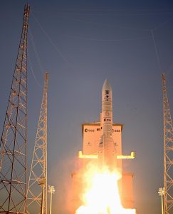
The satellite lifted off from Europe’s Spaceport in Kourou, French Guiana, on 4 November 2025 at 22:02 CET (21:02 UTC) aboard an Ariane 6 rocket.
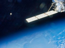
Thirty-four minutes later, Sentinel-1D was released into orbit, and at 23:22 CET, the first signal was received by the Troll ground station in Antarctica, confirming the successful deployment of the Copernicus satellite.
This launch ensures the continuity of Europe’s world-leading radar-based Earth observation system, keeping a constant watch on our planet – day and night, in all weather conditions.
Commenting on the launch success, Simonetta Cheli, Director of the European Space Agency (ESA) Earth Observation Programmes, said: “This launch on board Ariane 6 is an important one for ESA, as it completes the Copernicus Sentinel-1 mission – soon Sentinel-1D will be commissioned and fully operational, together with Sentinel-1C.
“The continuity of service this provides for the EU Space Programme is vital for addressing the global challenges we face.
“Citizens will benefit from the contribution this mission makes to scientific understanding of our environment – by providing accurate, reliable and actionable radar data on movements in our ice sheets, on our forest ecosystems, ground movements and much more.
“I thank all the teams involved: from the mission team at ESA to our many partners in European industry, including Thales Alenia Space, Airbus Defence and Space, and of course our partner for the Copernicus Programme, the European Commission.”
Strengthening Europe’s radar vision
The new Copernicus satellite will take over from Sentinel-1A, which has been in service since 2014, extending the mission’s capabilities well into the next decade.
Developed under the EU Space Programme in cooperation with the ESA, Sentinel-1D forms part of the Sentinel-1 constellation, renowned for its high-resolution synthetic aperture radar (SAR) imagery.
Unlike optical satellites, Sentinel-1D’s radar can see through clouds, darkness, and even rain – providing uninterrupted global coverage. Its radar instrument will deliver crucial data for environmental monitoring, maritime surveillance, and rapid emergency response.
Watching over a changing planet
Sentinel-1D’s data will be used to detect oil spills, track illegal maritime activities, and monitor natural hazards such as floods, landslides, volcanic eruptions, and earthquakes.
It will also support agricultural and forestry management, mapping land deformation, and observing the effects of climate change on glaciers, ice sheets, and coastlines.
The Copernicus satellite carries both a C-band SAR instrument and an Automatic Identification System (AIS) to track ships at sea. Together, these tools enhance maritime safety and environmental protection.
A Galileo-enabled navigation receiver on board also reinforces Europe’s space independence, ensuring precise positioning without reliance on non-European systems.
Teaming up with Sentinel-1C
Sentinel-1D will soon join its twin, Sentinel-1C, in orbit. The two satellites will operate 180° apart on opposite sides of the planet to optimise global coverage and ensure frequent revisit times.
Working together, they will deliver an uninterrupted flow of radar images and ship-tracking data to users worldwide.
Once fully calibrated, Sentinel-1D will begin supplying free and open data to governments, research institutions, and private companies, supporting applications ranging from environmental protection to security and sustainable development.
Proven technology with a global impact
Since the first Sentinel-1 satellite launched over a decade ago, the Copernicus programme has transformed how scientists and decision-makers observe Earth.
Its radar data have revealed land subsidence across Europe, tracked tropical deforestation through thick cloud cover, and measured ice loss in the Arctic and Antarctic.
Sentinel-1 data have also been critical for disaster response – from mapping flooding beneath Greenland’s ice sheet to monitoring earthquakes and massive methane leaks.
This vast, freely available dataset has become indispensable to climate scientists, environmental agencies, and emergency responders around the world.
A triumph of European collaboration
The Sentinel-1D mission represents years of collaboration between the European Commission, ESA, and European industry.
More than 70 companies contributed to its design and construction, led by Thales Alenia Space and Airbus Defence and Space – showcasing Europe’s technological excellence and commitment to sustainable innovation.
With the Copernicus satellite Sentinel-1D now safely in orbit, Europe continues to build its global leadership in Earth observation.
The mission not only ensures the continuity of vital environmental data but also strengthens Europe’s resilience, autonomy, and ability to respond swiftly to global challenges.
In the coming months, Sentinel-1D will undergo a rigorous commissioning phase before beginning full operations.
Once active, it will provide the world with an unblinking radar eye on Earth – capturing the planet’s movements, monitoring our oceans, and helping humanity better understand and protect its only home.