The PAVE-SCAN project aims to build EGNSS-based and AI-driven technologies for the high-accuracy, yet low-cost, assessment of roadway pavements, and to improve the safety of drivers and the operations and maintenance of roadway networks.
The maintenance, performance, and safety of roadway infrastructure are critical concerns for modern societies. Growing traffic volumes, rapid urbanisation, and ageing infrastructure increase the need for efficient and scalable methods for monitoring pavement condition. Detecting surface degradation (such as cracks, roughness, potholes, or deformation) at early stages allows timely maintenance, reduces operational costs, and enhances safety. Conventional inspection approaches, including manual surveys or specialised survey vehicles, are costly, labour-intensive, and difficult to perform at high frequency or across large networks.
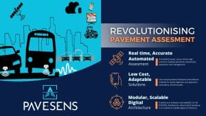
PAVE-SCAN, and the derived PAVE-SENS technologies, address this challenge through a scalable, low-cost, AI-enabled solution for continuous pavement assessment. Funded under Horizon Europe and supported by the European Union Agency for the Space Programme (EUSPA), the project combines low-cost sensing technologies, GNSS-based positioning, and data-driven analytics to monitor road conditions at high resolution and frequency. By leveraging vehicles already circulating on public roads, the project enables widespread and near-real-time insight into pavement health.
PAVE-SCAN aims to evolve beyond traditional inspection techniques, enabling public authorities and operators to make informed decisions, optimise maintenance cycles, and enhance network accessibility and safety.
Project objectives
PAVE-SCAN pursues five core objectives:
- Develop an integrated hardware-and-software platform using European GNSS positioning and low-cost sensors (e.g., vibration sensors, gyroscopes, OBD units), enhanced with machine-learning and machine-vision algorithms for automated pavement distress detection and classification.
- Enable pavement monitoring through participatory data collection, harnessing municipal fleets, road-maintenance vehicles, public transport fleets, and potentially citizen vehicles.
- Demonstrate and validate the platform through large-scale pilot deployments and reach near-market maturity (TRL8–9) by project completion.
- Deliver a system supporting continuous, network-wide monitoring to improve infrastructure planning, safety-focused interventions, and prioritised maintenance allocation.
- Generate value for municipalities, agencies, transport operators, and citizens by improving the transparency and accessibility of road-condition information.
Significance, innovation, and alignment with EU policy
PAVE-SCAN represents a shift from infrequent and expensive surveys to continuous, data-driven pavement management. Its approach aligns with EU digital-transformation priorities, particularly in:
- Advancing adoption of GNSS-based technologies (Galileo and EGNOS).
- Supporting sustainable development of transport networks.
- Improving long-term asset-management capabilities.
- Reducing disparities between municipalities with high and low technical capacity.
The project’s open-architecture design enables interoperability with existing pavement management systems, integration into municipal digital infrastructures, and potential commercial scaling. By stimulating service-based monitoring models and downstream applications of GNSS and AI, PAVE-SCAN fosters innovation, entrepreneurship, and smart mobility services.
Methodology
The methodology (Fig. 1) integrates modern sensing tools with advanced analytics and geographic decision-making frameworks:
- GNSS-based positioning and georeferencing
Using European GNSS receivers, sensor observations (e.g., vehicle vibration signatures) are accurately georeferenced. This is essential for locating defects spatially, linking anomalies to physical road segments, and supporting subsequent maintenance actions. - Low-cost sensors and participatory sensing
PAVE-SCAN replaces specialised platforms with affordable sensors mounted on existing fleets. These include vibration and gyroscope sensors, OBD feeds, and potentially cameras or LiDAR, enabling continuous monitoring under real operating conditions. - Machine-learning and machine-vision analytics
AI models classify pavement defects, identify roughness patterns, and infer deterioration trends. The modular design allows expansion to new road types, climatic regions, or dependability requirements. - GIS integration and decision-support tools
Detected anomalies feed into GIS-based pavement-management systems, allowing:
- Prioritisation of repairs.
- Budget-optimised maintenance planning.
- Dynamic monitoring of degradation across time.
- Pilot deployments as urban living labs
Validation occurs in Cyprus, Malta, Spain, Italy, and Estonia. Each location offers unique infrastructure characteristics, vehicle profiles, traffic dynamics, and climatic exposure, strengthening transferability and generalisation of results.
Key results and contributions
The project’s work to date demonstrates the feasibility and disruptive potential of low-cost, crowd-sourced pavement monitoring:
- Vehicle-mounted vibration sensors combined with GNSS positioning and cameras can identify pavement surface irregularities with significant reliability.
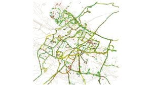
- Point-level roadway assessment can lead to direction-level and street-level assessment and roadway-network mapping (by use of GIS), complemented with supporting video/images, and the underlying ML-processed datasets form the basis for pavement management systems (Fig. 2).
- Detection of condition deterioration correlates well with roughness metrics used by existing pavement-management frameworks.
- Scaling via participatory sensing enables frequent updates at a fraction of the cost associated with professional surveys.
- Analysis pipelines convert raw sensor signals into surface-condition indices and location-tagged insights suitable for GIS-based infrastructure dashboards and a pavement management system.
- Pilot deployments confirm reproducibility across different vehicle types and road environments, with continued improvements under algorithm retraining.
Further developments strengthen automation of defect classification through machine-vision modules, enabling the detection of cracks, potholes, or ravelled surfaces using camera feeds. Parallel work explores predictive analytics for estimating future deterioration, supporting preventive maintenance scheduling rather than reactive repairs.
These advances demonstrate clear disruption potential, validating that AI-based, low-sensor-cost approaches can meaningfully support municipal maintenance operations.
Outlook and upcoming activities
As the PAVE-SCAN platform advances toward large-scale demonstration and market entry, forthcoming steps include:
- Scaling deployment
Pilot environments will contribute high-density ground-truth datasets. Municipal fleets, public transport vehicles, and road-service units will be progressively equipped with the system.
- Enhancing detection capabilitiesMachine-vision integration and multi-sensor fusion will extend detection beyond roughness to include visual defects and structural deterioration indicators.
- Real-time monitoringTransition from asynchronous data uploads to near-real-time interfaces will improve live asset-management responsiveness.
- CommercialisationThe project aims to deliver modular service offerings suitable for municipalities and mobility authorities, outsourced infrastructure-management agencies, and smart-city digital-twin environments.
- Standardisation and EU-wide adoptionEfforts will emphasise data governance, privacy handling, interoperability, and harmonised road-condition reporting formats.
Consortium and project implementation
Coordinated by the University of Cyprus, the consortium includes 13 partners from seven EU countries, bringing together academic institutions, technology providers, transport operators, municipalities, and innovation-commercialisation entities. This multidisciplinary composition enables technical excellence, domain validation, and pathways to long-term uptake.
The project runs from January 2024 to December 2026 and targets deployment-ready outcomes via its integrated hardware-software digital platform.
Funding Acknowledgement

PAVE-SCAN is funded under the Horizon Europe programme with support from EUSPA, Grant Agreement No. 101131910, with a total budget of approximately €3m.
This article will feature in our upcoming space Special Focus Publication.
Please Note: This is a Commercial Profile

This work is licensed under Creative Commons Attribution-NonCommercial-NoDerivatives 4.0 International.