The DISPEC project merges science, AI, and open data for operational resilience and scientific excellence.
The ionosphere, the ionised component of the upper atmosphere extending from 90-1000 km above the Earth, plays a critical role in modern infrastructure. It affects everything from aviation and navigation to radio communications and emergency services.
The DISPEC project is advancing our understanding of how to monitor and understand this vital part of our atmosphere. This is important because improved forecasting and long-term monitoring lead to more resilient communications, enhanced GPS accuracy, and stronger preparedness for space weather disruptions.
Working with PhD students and early-career scientists, DISPEC researchers combine satellite and ground-based data with state-of-the-art data processing and artificial intelligence to provide more accurate and reliable insights into ionospheric conditions.
The scientific development under DISPEC relies on accurate and timely space environment data collected by networks of ground-based and spaceborne platforms. These platforms feed real-time data into space weather forecasting systems and support operations such as radar functionality, satellite control, direction finding, and high-precision navigation and positioning.
Why data accuracy matters
Given the operational significance of these systems, the accuracy and reliability of the data used to characterise near-Earth space is of paramount importance. However, data integrity can be compromised due to:
- Instrumental issues (e.g., calibration errors, hardware degradation)
- Environmental effects (e.g., geomagnetic and tropospheric storms)
- Misinterpretation or faulty post-processing caused by ionospheric irregularities
Digisonde stations are ionospheric sounders that gather valuable ionospheric data, not only thanks to the global coverage of their network Global Ionosphere Radio Observatory (GIRO) but also because they routinely provide analytical information regarding the formation of electron layers from 90 km up to the height of the peak electron density.
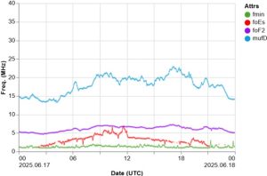
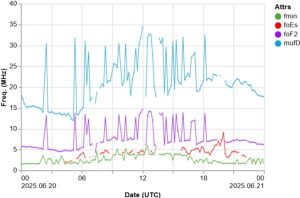
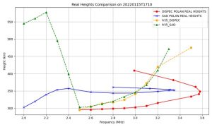
Data quality issues may lead to time series of critical ionospheric characteristics containing outliers and gaps (Fig. 1), rendering them unsuitable for scientific and operational use.
Each data point in Fig. 1 is extracted through the analysis of an ionogram. Interpretation errors in the raw ionogram image can lead to faulty conclusions.
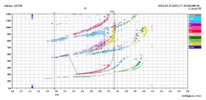
Fig. 2 shows an example of an ionogram recorded by the Athens Digisonde, where automatic interpretation is compromised due to multiple reflections above the main trace.
Addressing the challenges associated with data quality
The EU-funded DISPEC project addresses these challenges by generating high-level data products derived from raw ionospheric observations (Fig. 3).
By cross-validating data sets and improving processing algorithms, DISPEC aims to:
- Enhance the scientific accuracy of ionospheric models
- Improve space weather predictions
- Ensure operational robustness of space-based services
A recent report submitted to the EC looks at early results from a DISPEC method for automatically analysing ionograms. This method mimics the process a trained expert would follow to estimate key parameters such as the maximum usable radio frequency (foF2) and the F2-layer height (hmF2).
Key innovations include:
- AI-based ionogram interpretation, improving the precision of key ionospheric measurements (e.g., foF2 and hmF2).
- Open-source tools (e.g., POLAN) are integrated with automated workflows to ensure transparency and usability.
- New filtering methods that replicate expert-level analysis and reduce noise in raw data.
The DISPEC methodologies and AI/ML models will be shared with students and early-career researchers during a school organised by the project in Fall 2026 in Greece. We invite all stakeholders to follow our updates and join our planned activities.

The DISPEC project is funded by the European Union (GA 101135002).