With new applications and a project backed by the European Space Agency, RSS-Hydro is poised to revolutionise the field of Earth observation.
Imagine a world where floods are detected and alerts are sent with pinpoint accuracy weeks in advance, where urban development is meticulously planned based on real-time environmental data, and where the impact of climate change is tracked with unprecedented detail. This is not science fiction; it’s the rapidly evolving reality powered by groundbreaking innovations in space platforms, satellite communications (satcom), and Earth observation (EO) missions. Companies like Luxembourg-based RSS-Hydro, with cutting-edge applications like FloodSENS and its new project CeDaRS, supported by the European Space Agency (ESA), are at the forefront of this revolution, demonstrating the transformative potential of an ‘all-in-space’ approach to understanding and managing our planet.
For decades, Earth observation from space has provided invaluable data for weather forecasting, environmental monitoring, and disaster response. However, recent technological leaps are ushering in a new era of capabilities, making EO more precise, timely, and accessible than ever before.
The dawn of advanced space platforms
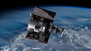
The traditional model of large, monolithic satellites is being disrupted by the rise of smaller, more agile platforms. CubeSats and SmallSats, often deployed in constellations, offer increased revisit times, meaning they can image the same area much more frequently. This high temporal resolution is crucial for dynamic events like flood monitoring, where near real-time data is essential for effective response. Furthermore, these smaller satellites can be launched more affordably, democratising access to space-based data collection. Companies are also exploring innovative platform designs, including cloud computing infrastructure and modular systems, allowing for greater flexibility and adaptability in orbit.
Satcom supercharging data delivery
The sheer volume of data generated by advanced EO missions demands robust and high-speed communication links. Advancements in satcom are meeting this challenge. Laser communication promises significantly higher data transfer rates compared to traditional radio frequencies, enabling the downlink of massive datasets in a fraction of the time. Inter-satellite links, where satellites communicate directly with each other, create resilient networks that can bypass terrestrial infrastructure, ensuring data reaches users even in remote or disaster-stricken areas. The development of software-defined satellites allows for on-orbit reconfiguration of communication payloads, providing the flexibility to adapt to changing data demands and user needs.
Earth observation missions: A new level of detail
The EO missions themselves are undergoing a radical transformation. Hyperspectral imaging, capturing data across hundreds of narrow spectral bands, provides a far more detailed ‘fingerprint’ of the Earth’s surface, enabling precise identification of vegetation types, soil composition, and even water quality. Synthetic aperture radar (SAR) technology and other microwave systems, a cornerstone of many flood mapping applications, can penetrate clouds and darkness, providing critical information during severe weather events when optical sensors are limited. The integration of artificial intelligence (AI) and machine learning (ML) on board satellites allows for real-time data processing and analysis, extracting actionable insights before the data even reaches the ground. This on-orbit intelligence is crucial for rapid disaster assessment and environmental change detection.

RSS-Hydro: Pioneering integrated space solutions
RSS-Hydro exemplifies the power of these integrated space solutions. It is developing an all-in-space service solution, called FloodPin, that leverages satellite imagery, combined with hydrological know-how and AI, to provide accurate and timely flood insights and impact assessments. This capability is a gamechanger for disaster preparedness and response, allowing authorities and communities to take proactive measures to mitigate damage and save lives.
Furthermore, their project CeDaRS (Comprehensive space-tech powered Disaster Response Solution), supported by ESA, highlights the importance of advanced data processing and analytics. Extracting meaningful information from the vast amounts of EO data requires sophisticated algorithms and infrastructure.

CeDaRS, in this context, represents the development of tools and techniques to transform raw satellite data into rapid and actionable intelligence for various applications. For RSS-Hydro, the focus is on flood detection and alerting, but CeDaRS will pave the way for an all-in-space EO solution infrastructure to enable smarter, more secure, and more sustainable services for a vast number of application domains, such as infrastructure monitoring, disaster and environmental management, urban planning and, more generally, for civil security,
Focusing on disaster management, the innovation of CeDaRS lies in an all-in-space processing architecture for rapid disaster intelligence. By deploying advanced algorithms directly in orbit on satellite infrastructure, it drastically reduces the latency in generating and delivering critical information following a disaster. This approach bypasses traditional ground-based processing bottlenecks, enabling near real-time insights – such as event mapping and initial impact assessments – to reach stakeholders within minutes. This speed and efficiency are crucial for timely and effective emergency response across various disaster types.
The broader impact: A smarter, more sustainable future
The convergence of advanced space platforms, high-throughput satcom, and sophisticated EO missions is creating a paradigm shift in how we interact with our planet. This ‘all-in-space’ approach offers numerous benefits:
- Enhanced disaster management: Early warning systems for floods, wildfires, and other disasters become more accurate and timely, allowing for better preparedness and response.
- Urban planning and infrastructure management: Real-time data on urban sprawl, traffic patterns, and infrastructure health allows for smarter and more sustainable development.
- Environmental monitoring: Tracking deforestation, pollution, heatwave impacts, and other environmental changes with unprecedented detail enables more effective conservation efforts and policy decisions.
- Climate change monitoring: Comprehensive and continuous Earth observation provides crucial data for understanding the complex processes driving climate change and for monitoring the effectiveness of mitigation strategies.
Looking ahead
The synergy of advanced space platforms, high-throughput satellite communication, and sophisticated EO missions is driving a paradigm shift, leading to new service architectures and business models akin to cloud service provision. This convergence is fundamentally changing how we interact with our planet.
The field of space-based Earth observation is poised for even more dramatic advancements. The integration of data from multiple satellite constellations, combined with in-situ sensors and ground-based information, will provide an even more holistic view of our planet. The increasing use of AI and cloud computing will further enhance data processing and accessibility, making EO insights available to a wider range of users.
As companies like RSS-Hydro continue to innovate and push the boundaries of what’s possible, the ‘all-in-space’ vision of a comprehensively monitored and understood Earth is rapidly becoming a reality. This new era of Earth observation promises a future where we are better equipped to manage our planet’s resources, respond to challenges, and build a more sustainable and resilient world for all.