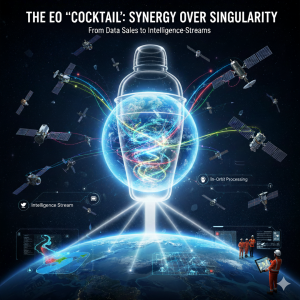
A ‘cocktail’ approach to Earth observation could integrate diverse data from multiple providers to deliver actionable intelligence quickly and affordably for effective decision-making across various sectors.
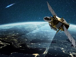
The foundational model of the Earth observation (EO) sector – selling high-cost, single-source imagery – is no longer sustainable. The traditional EO market, built on the premise of selling raw pixels as a commodity, may be dying. We are now in a golden age of satellite data, with more constellations – both public and commercial – than ever before.
Yet, the data market remains stuck in the analogue era, prioritising the sale of costly, siloed, raw images, where the narrative is dictated by big players in the market selling to big spenders. This antiquated model is crippling the potential of space-based intelligence, hindering everything from infrastructure planning to, most critically, information intelligence and disaster response, for which the narrative could actually be superior.
The current challenge is not a lack of data; it’s a lack of intelligent, affordable access. We need a fundamental market disruption: a shift from selling expensive, single-source raw images to delivering an agile, processed ‘cocktail’ of multi-provider data – actionable intelligence streams, ready to be deployed instantly, whether in orbit or on the ground. The sustainability of the entire EO ecosystem – and the safety of the planet’s inhabitants – depends on embracing this collaborative future.
The single-image trap
For decades, the standard business model in commercial EO has been straightforward: launch a high-resolution satellite, take a picture, and sell that image at a premium. This model made sense when satellites were scarce, costly government assets, or pioneering private ventures. Today, however, it is an impediment.
This paradigm forces customers – from private cooperatives and national mapping agencies to humanitarian aid organisations – to become expert data wranglers. They must navigate a fragmented landscape of dozens of vendors, each offering a proprietary sensor type (high-resolution optical, Synthetic Aperture Radar (SAR), hyperspectral, etc.) under different licensing terms and at prohibitive price points.
The result is a system characterised by:
- High cost & low access: The sheer expense of purchasing multiple, overlapping high-resolution images prevents sustainable, large-scale uptake. Only the wealthiest organisations can afford consistent coverage, leaving much of the public sector, NGOs, and developing nations behind.
- Data silos: Each vendor’s product is treated as a discrete, standalone good. This forces analysts to manually fuse incompatible datasets, delaying analysis and often leading to inferior results compared to a harmonised stream.
- Latency in crisis: In a disaster scenario – a sudden flood, a landslide, or a wildfire – every hour counts. Waiting for a single commercial provider’s operations and ground stations to align, placing a costly rush order, receiving the raw data, and then processing it wastes critical time. The traditional model is fundamentally incompatible with the urgency of rapid intelligence, emergency response and humanitarian aid.
The EO ‘cocktail’: Synergy over singularity
The future of Earth Observation is not about the dominance of a single, spectacular sensor; it’s about the synergistic blend of many. This is the EO Cocktail approach.
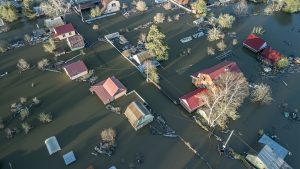
Imagine a user needing to assess flood damage. They don’t just need one image. They need critical intelligence fast, made up of many different images and data types, and easily digestible by humans and LLMs for quick, actionable decision-making. For this particular example of flood damage, such a data cocktail would need to be composed of: images that see through clouds and capturing the extent of the water at night, if need be; for context, land-cover classification, and pre-event baselines; very high images and IOT sensors for precision damage assessment of critical infrastructure (bridges, power plants); and topographic data, crucial for hydrographic modelling and predicting water movement.
A single provider cannot feasibly supply all this data, nor can a single sensor deliver the necessary fidelity and frequency simultaneously. The cocktail model proposes an intelligence layer that automatically blends these inputs from both the public domain (like the free and open data from Copernicus/Sentinel and Landsat) and the commercial sector.
The value proposition shifts entirely. The customer no longer pays a high price for a raw VHR image; they pay an affordable, subscription-based fee for a consistently updated ‘Flood Intelligence Stream’ aka ‘FloodPin’ – a processed, harmonised product ready for immediate use. This maximises the return on investment from public satellites while ensuring a clear, sustainable business model for commercial operators who specialise in providing supplementary, high-value data components.
From data sales to intelligence streams
This revolution necessitates a complete re-engineering of the supply chain, transforming the market from a commodity business (selling pixels) into an essential utility (selling insights).
The latency imperative: In-orbit processing
One of the most radical shifts is the move toward onboard processing. For time-critical applications like disaster monitoring, fetching petabytes of raw data down to Earth, processing it in a ground station, and then routing the derived intelligence back to the field is a recipe for delay.
Next-generation satellites and constellations, or entire orbital cloud computing infrastructure, are incorporating powerful processing capabilities – often powered by AI and Machine Learning (AI/ML) chips – that can perform crucial analytical tasks in orbit. For instance, a satellite could identify a newly formed flood boundary over a remote area, compress that single piece of information, and immediately downlink the small data package to a nearby tactical ground station or even directly to a handheld device.
This approach drastically reduces the reliance on ground infrastructure, cuts latency from hours to minutes, and minimises bandwidth requirements – a critical factor for providing reliable, high-fidelity intelligence in disconnected, crisis-affected regions.
The power of the service model
On the ground, the new ecosystem thrives on Data-as-a-Service (DaaS) or, more aptly, Intelligence-as-a-Service (IaaS). Companies that excel in this new era will be the mixologists – the platforms that can ingest, clean, harmonise, and analyse the data cocktail, selling the derived answer rather than the raw ingredients.
This is precisely the kind of innovation pioneered by companies like RSS-Hydro with their tools like FloodPin. These systems leverage the rapid, multi-sensor approach to deliver near real-time flood monitoring and disaster assessment. They are not selling a Sentinel image or a commercial image snapshot; they are selling a precise, time-stamped intelligence of the impact – a life-saving piece of intelligence. By focusing on the solution, they demonstrate how to achieve speed, accuracy, and ultimately, affordability.
The imperative: Affordability and sustainable uptake
The need for this market disruption is not merely a matter of technological progress; it is an economic and ethical imperative.
Sustainable uptake
The current high-cost model is the single greatest barrier to sustainable uptake by the public and private sectors. Governments need consistent, multi-year, continental-scale monitoring for climate adaptation, infrastructure planning, and complete ecosystem management. They cannot budget for the ad hoc, high-cost purchasing of single images. An affordable, reliable IaaS subscription, offering guaranteed, harmonised intelligence streams, enables consistent budgetary planning and widespread integration of EO data into daily operations. This stable revenue stream, in turn, allows commercial providers to invest confidently in innovation.
Democratising disaster response
In the context of humanitarian response, the market’s failure to provide affordable, rapid intelligence is a crisis in itself. When a Category 5 hurricane strikes a low-income nation or, indeed, a high-income nation, the inability of local authorities or aid groups to rapidly access and afford the most precise information translates directly into a higher loss of life and greater economic damage.
By shifting to the ‘cocktail’ model, the global community ensures that essential, life-saving intelligence becomes an affordable utility. It guarantees that the best possible picture of the ground – fused from NASA, ESA, JAXA, and dozens of private companies – is not reserved for the highest bidder, but deployed instantly to the most vulnerable communities.
The era of a rather costly, single, freshly acquired satellite image must end. The future of Earth observation is collaborative, automated, and built on the foundation of the affordable, multi-source intelligence stream. Only then can we truly fulfil the promise of space technology: to serve as the planet’s essential, reliable eyes, working tirelessly to protect and sustain life on Earth.
Please note, this article will also appear in the 24th edition of our quarterly publication.