RSS-Hydro is improving access to real-time geospatial data through innovative services like FloodSENS and FireSENS, enabling proactive decision-making to enhance public safety and disaster management.
RSS-Hydro is leading a shift in natural disaster management, moving public safety from reactive to proactive. The Luxembourg-based company is leveraging cutting-edge technology and a unique business model to address the escalating risks of water and fire-related hazards.
Its mission is to democratise high-value geospatial data, specifically by transforming the complex outputs of satellite Earth observation (EO) applications like FloodSENS and FireSENS into intuitive, affordable compressed intelligence products called ‘Pins.’
The core mission: EO for all
The company’s strategy overturns the traditional model of delivering complex, bespoke services only to a few experts. RSS-Hydro’s philosophy is to: ‘Sell very affordably to many instead of just a few EO experts. Sell to all with the right, clear message to manage disasters better.’

By making this critical intelligence accessible and easy to interpret, they empower everyone – from emergency managers, first responders, city officials, to individual drivers – to make informed, split-second decisions that can save lives and reduce economic impact.
From static maps to dynamic intelligence
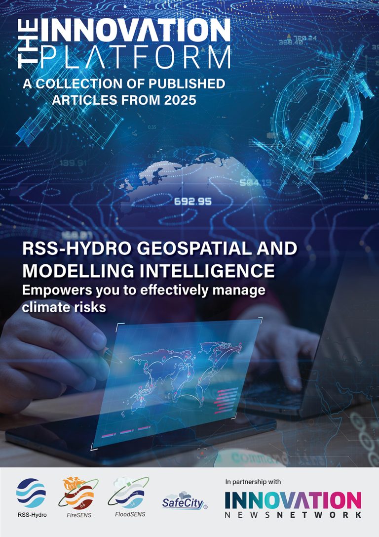
Traditional disaster management often relies on several days’ old data, a firehose of geospatial maps of different complexities, and generalised models. While useful for long-term risk assessment (e.g., a ‘100-year flood risk’ map), these tools cannot provide the real-time updates and predictions needed during a rapidly unfolding event, like a flash flood, for instance.
RSS-Hydro’s (Flood)Pin service fundamentally changes this by creating a continuously updated ‘intelligence’ set, specifically focused on water risk parameters, which starts with frequently refreshed predictions, and switches to observations as these become more readily available.
1. The technology foundation: FloodSENS and Data Fusion
RSS-Hydro’s services are built upon the synergy of advanced data sources and powerful computational methods.
FloodSENS: This satellite Earth observation application uses advanced machine learning to interpret data from various sources, including optical and radar sensing, allowing it to accurately identify and map flooded areas globally, even under adverse weather conditions.
Observation intelligence: This EO data could then even be further combined with real-time ground-based data from smart city infrastructure, such as water level sensors in rivers and storm drains, connected vehicles, and citizen-provided information. This data fusion creates an accurate, real-time picture of current conditions, pinpointing water risks with unprecedented precision, such as reporting that a road is flooded at 30 to 40 cm deep.
2. The innovation of the Pin: Predictive and sector-specific
The true power of the ‘Pin’ lies in combining this real-time observation intelligence with predictive analytics.
Predictive capabilities: Using sophisticated weather forecasting and early warning models, the system analyses weather forecasts, land topography, infiltration capacity, and water flow to infer future flood scenarios. This enables a level of proactive decision-making that was previously not really possible.
Sector-specific parameters: The Pin moves beyond just the hazard extent (like a flood map) and integrates contextual data layers to assess immediate impact, such as overlaying critical assets (substations, roads) or population density.
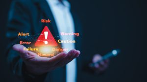
3. Transforming public safety decisions
This intelligence is delivered to various stakeholders, enabling tailored, life-saving actions:
A universal language of safety: The LLM integration
One of the most significant challenges in an emergency is the language barrier, where communication must be clear and understood by everyone. The integration of the Pin’s intelligence with a Large Language Model (LLM) is a true game-changer.
Multilingual communication: By feeding the precise data from FloodPin into a sophisticated LLM, the system can instantly translate critical safety messages into any language or local dialect.
Actionable instructions: The LLM crafts unambiguous, culturally sensitive messages, translating complex data (e.g., ‘water depth at intersection X is 60 cm and rising’) into a simple, personal, and actionable instruction, such as: ‘The road ahead is dangerous. Turn around now and take the street on your right. You will be safe there.’
This ability to communicate with everyone, everywhere, in their own language, ensures safety is truly universal.
In the end, what makes FloodPin a game-changer isn’t just its advanced technology; it’s the seamless integration of that technology into the human experience. It transforms our smartphones and cars into proactive messengers, helping us navigate a world of increasing uncertainty and risk.
The Pin as a blueprint for universal resilience
The revolutionary ‘Pin’ concept, starting with FloodPin, is merely a blueprint for a wider array of hazard intelligence services that RSS-Hydro develops. The exact same architecture – fusing satellite EO, ground-based observation intelligence, predictive modelling, sector-specific parameters, and LLM-driven communication — is directly transferable to other hazards, particularly wildfires. FireSENS, for example, uses near-real-time thermal data from satellites (Fire Radiative Power analysis) and fuses it with demographics, critical infrastructure and other asset data. A resultant FirePin would not only show the current perimeter and intensity of a wildfire but would include vulnerable populations and critical infrastructure in the fire’s forecasted path. This allows authorities to issue precise, multilingual evacuation orders, prioritise the protection of key assets (like electrical substations), and guide emergency vehicles along safe, predicted routes.
Whether tracking rising water or a spreading fire, the ‘Pin’ represents the same core innovation: the seamless integration of advanced technology into the human experience. It transforms ‘fear’ into ‘foresight’, ensuring that complex, data-driven insights are instantly translated into the personal, split-second decisions that save lives and build genuine global resilience.
The logical next step in this evolution is the creation of a SafePin – a generalised safety Pin that moves beyond natural hazards into the realm of human-caused or public security issues. By leveraging the same core ML algorithms to detect anomalies from satellite and connected ground sensors, SafePin could identify unusual concentrations of people or vehicles, track the spread of a chemical spill plume based on atmospheric data, or predict security risks in real-time urban environments. The system’s strength lies in its ability to combine diverse data streams – from thermal satellite images to city IoT networks – and, crucially, use the LLM to deliver context-aware, hyper-localised instructions (e.g., ‘stay indoors, toxic fire smoke is predicted to pass in ten minutes,’ or ‘avoid area A due to unconfirmed security incident’). This extension of the Pin technology creates a truly comprehensive Public Safety Network, transforming data from a simple map into an omnipresent, intelligent messaging service that helps keep people safe.
Please note, this article will also appear in the 25th edition of our quarterly publication.