AscendXYZ is disrupting the bird strike prevention market with the world’s first airline-centric solution – Ascend Avian Radar Network (AARN).
Ascend provides a series of solutions all aimed at the reduction of bird strikes in aviation. Over the last five years, these solutions have been implemented in Aalborg Airport with amazing results – after implementing the avian radar, the number of strikes in 2018 dropped by 75%. The next step is to make the radar-measured bird risk forecasts available to airlines and pilots. This works like a weather forecast and enables pilots to mitigate the risk when the probability of a strike is high.
The nature of the aviation industry makes it uniquely vulnerable to a multitude of elements, ranging from airports operating their runways at 99% capacity to collisions between birds and aircraft. Bird strikes are an increasing problem for the aviation safety. US Federal Aviation Authority (FAA) reported a 38% growth in bird strikes from 2009 to 2015 and has noted that bird strike incidents have shown an alarming trend of significant growth.1
One of the problematic aspects in minimising bird strike risk in aviation is the fact that responsibility and cost distribution is quite complicated; active mitigation is in the hands of airports, while major costs are incurred by airlines without having the possibility to mitigate the risk more proactively. Bird strikes are an industry problem; thus, seeking noticeable results should be tackled by all parties. Therefore, after a close collaboration with the industry, AscendXYZ introduced a new approach and suitable solutions both for airports and airlines.
Airport solution – AscendXYZ Avian radar
One of the tools that has already been proven to be effective in mitigating bird strikes is avian radar data. AscendXYZ Avian radar is not just a radar; it is a solution that allows the user to predict bird activity and minimise the bird strike risk while at the same time having an overview of the airport area. Furthermore, the solution provides real-time guidance for bird control staff, enabling a swift and effective response.
AscendXYZ Avian Radar solution makes it all possible whilst also giving access to automated reports and KPI’s that can be integrated smoothly into existing wildlife risk management programmes with minimal work on airport’s end.
AscendXYZ Avian Radar solution is an easy-to-use end-to-end service delivered in an intuitive interface together with automated reports that leave hands free to act. The system is delivered as a service, so the user does not have to think about maintenance or insurance – they only need to focus on the results.
Being an expert aviation software company enabled Ascend to develop disruptive applications and rewrite the software of existing commercially off-the-shelf radar systems to deliver the most cost-effective Avian Radar solution on the market.
AscendXYZ Avian Radar:
• 24/7 Radar detection of birds – easy to use end-to-end service that covers up to 150km2;
• Real-time bird control guidance – solution evaluates and relays bird activity to the bird control units in real time. The information enables bird controllers to see where and when birds enter the operations area. This allows birds to be dispersed quickly and efficiently, making the airport area an unattractive feeding ground;
• Bird activity forecast – enables the planning of appropriate mitigative actions and staff effort during high-risk periods without interrupting airport operations; and
• Bird hot-spot identification – pinpoints problem areas in and around the airport and helps to take action to minimise future risks. By analysing the historical radar data, bird activity hot spots and local migration routes can be identified, documented, and included in the risk assessment.
The best results are achieved employing a holistic approach and by combining new measures to get quality data about wildlife behaviour. AscendXYZ users can complement radar data by using the AscendXYZ Wildlife Registration solution, allowing them to register wildlife with just a few touches on a tablet or smartphone – on site, with a direct view of the situation.
The service is available as an app for mobile phones and tablets, and data is available immediately, 24/7, in a dashboard or as reports for management, specialists, and bird controllers. The user can easily add new species, bird controllers, wildlife risk levels, and more to reports through the web portal, allowing them to work flexibly and efficiently.
A successful case of combining avian radar with other data capture measures was seen at Aalborg airport in Denmark. By holistically focusing on active measures (extra ‘boots on the ground’) in high-risk periods, new tools (AscendXYZ Avian radar and the Wildlife Registration solution, remote controlled gas canons, structured hunts, etc.), combined with education for the bird control units and strong management support, enabled Aalborg airport to achieve great results, dramatically decreasing bird strike risk.2
The world’s first airline-centric solution – Ascend Avian Radar Network
Any disturbance to air traffic leads to costly delays for both airlines and passengers and is one of the biggest dangers to profitability in the aviation industry. Major airlines experience bird strikes daily.
United Airlines estimates that, on average, each delay when an aircraft is struck by a bird, results in four secondary delays or cancellations to the subsequent flights.3 In addition to the direct maintenance costs (including replacement parts, inspection costs, etc.), the indirect costs of bird strikes are also of concern. These costs arise in case of a precautionary return to airport, aborted take-off, or engine shutdown, and can include: rerouting passengers, crew and passenger accommodation, burned fuel replacement, contractual penalties, additional airport or air traffic control charges, or loss of confidence and perceived damage to the airline brand.4
Historically, airport safety and wildlife management (and, in some cases, bird control units) were considered to be the main users of avian radar data. However, Aalborg Airport has, in collaboration with AscendXYZ, identified that pilots, airline safety management, and flight operations’ departments can also benefit from the data.
AscendXYZ is therefore introducing the world’s first airline-centric solution – Ascend Avian Radar Network (further-AARN). AARN connects multiple AscendXYZ (and third parties’) radars in multiple airports to deliver real-time bird activity data, forecasts, and warnings of high-risk periods to airlines and their pilots in all participating airports that the airline chooses to include in its subscription (of Ascend services). This means that the AARN enables airlines to take a proactive approach to minimising the risk of a bird strike by mitigating it from operational and planning perspectives.
The goal of the AARN is clear – to improve airline profitability while increasing flight safety. The solution is tailored for pilots (allowing them to check bird activity and forecasts from anywhere in the pre-flight phase or in the air), airline operations, safety management, and route-planning units (allowing predictions to be viewed in real-time and the risk analysis of individual airports to be accessed).
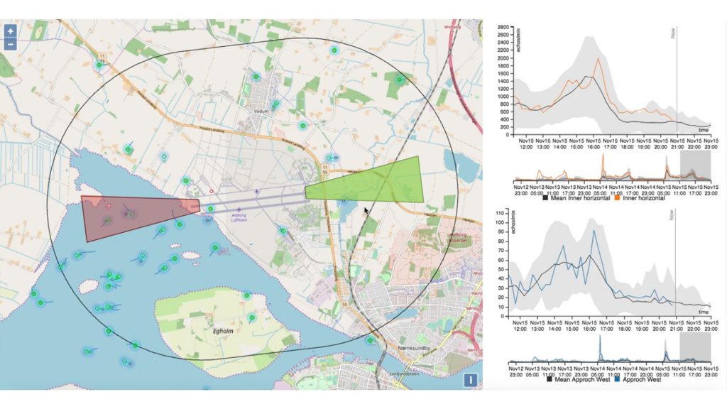
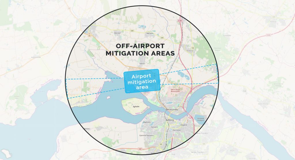
Civil and military airports have been managing the bird strike risk within the airport area by taking mitigating actions to disperse birds, while off-airport mitigation areas have not been covered. In reality the airports have little possibility to perform mitigation in this area, since it is owned by a third party. The AARN solution will make it possible for airlines to mitigate risk in the airline mitigation areas.
“By including airline flight operations and pilots in the risk mitigation we can significantly improve flight safety by enabling pilots and airlines to act on the bird risk and hazard monitoring from an operational perspective.” (Peter Hemmingsen, CEO at AscendXYZ)
There is nothing like the AARN on the market today. Thus, it is currently impossible to forecast bird activity in the destination airport, making the mitigation of bird strikes at landing unrealisable. There are no other radar systems that offer real-time data and risk prediction to pilots or direct integration into the airline safety management and route planning.
The AARN is a comprehensive solution consisting of radar software/hardware and cloud-based software, which makes it possible to perform complex radar configuration in a centralised manner. It is a network of ‘plug and play’ devices – all the airports have to do is provide power and Internet, while AscendXYZ takes care of uptime and maintenance.
The AARN solution will enable pilots to easily access the reliable and valuable information at any time in the pre-flight phase or during flights either directly integrated into existing electronic flight bag solutions (EFBs) or as part of crew briefing packages.
When the AARN identifies a peak bird activity period, it will send a notification to the pilot app allowing pilots to make the best possible decisions. Based on that information pilots then can:
- Use this information to prepare for the event of a strike, via approach and departure briefings;
• Increasing rate of climb to reduce time spent in a high-risk area;
• Increase climb gradient to outclimb the risk area – if the area is close in, this also means traveling a shorter distance in a high-risk area;
• Consider take-off or approach in opposite direction if risk is lower at one runway end (see Fig. 2); or
• Reduce speed on approach to reduce the impact energy in case of a strike. In many cases, a speed reduction is possible, also leading to a slightly prolonged airborne. However, this is just one to two minutes of the flight, and only when a radar detected high bird activity message is given.
Furthermore, airline safety management and route planning teams will have access to historical analysis of the data and will be able to extract radar risk assessment for individual analysis of existing or future destinations. By doing so, the airline could potentially aim to plan departures and arrivals at high-risk destinations at the times with the lowest predicted bird activity. This would typically be possible on transcontinental flights or when operating at regional airports. In the busiest airports, the aircraft will have to depart at assigned time slots and mitigate the risk from an operational perspective.
The AARN is an industry solution to minimise risk and improve operations, resulting in a positive financial business impact to airlines and increased flight safety to pilots/crew and passengers alike. Thus, AARN proves a range of benefits, including:
- The AARN prediction and real-time bird activity monitoring in a standardised format will enable the pilots, airline safety, and flight operations units to access the information needed to act and mitigate the risk and decrease subsequent cost;
• AARN is the only solution available on the market that supplies information to airlines from multiple radars; and
• The AARN is offered on an as-a-service basis, meaning that the airlines have no CAPEX.
About AscendXYZ
AscendXYZ specialises in developing easy to use as-a-service solutions for the aviation industry, such as data collection and data analysis regarding bird flight activity. The aim is to help airports and airlines avoid expensive and potentially dangerous bird strikes by revolutionising the way these are dealt with. Furthermore, AscendXYZ is offering radar-based solutions to other markets, drone risk assessment, and other SaaS products.
AscendXYZ has an international team of experienced entrepreneurs and highly skilled developers, engineers, and data science experts working in close collaboration with industry specialists.

The AARN project has received funding from the European Union’s Horizon 2020 research and innovation programme under grant agreement No 880308.
References
- FAA (2016), M. Hale, A. Koros, Wildlife Surveillance Concept — Avian Radar Knowledge Elicitation Activity 1
2. https://ascendxyz.com/2018/05/30/bird-strikes-down-by-50-in-aalborg-airport/
3. Allan, John R. and Orosz, Alex P., “THE COSTS OF BIRDSTRIKES TO COMMERCIAL AVIATION” (2001). 2001 Bird Strike Committee-USA/Canada, Third Joint Annual Meeting, Calgary, AB. 2. https://digitalcommons.unl.edu/birdstrike2001/2
4. M. Robinson, IS THE POSSIBILITY OF A COSTLY AIRCRAFT BIRD STRIKE GROWING?, Proceedings of International Bird Strike Committee, April 17-21, 2000, Amsterdam, Netherlands, pp:169-178
Please note, this article will also appear in the eighth edition of our quarterly publication.