Apostolos Tzimas explains more about the PrimeWater Project, which delivers high reliability water quality forecasts for the water industry to manage hydro-ecological hazards exposure and support vulnerability reduction.
Funded by Horizon 2020, the PrimeWater research project builds on advanced Earth observation (EO) data products to generate information on the effects of upstream changes on future water quality and quantity. The project will integrate EO products with additional data sources and diagnostic modelling tools to deliver increased situational intelligence, enhanced predictive and early warning capabilities, and the adaptive management of water resources.
To learn more about the project, The Innovation Platform spoke to Apostolos Tzimas, Managing Director and PrimeWater Project Coordinator at the EMVIS Water Resources & Environmental Management, which leads the project.
What challenges is the project addressing?
As water management operations are growing in importance and complexity, challenges regarding regulatory compliance, risk management and cost optimisation become critical determinants of the sustainability of water services to the environment, businesses, and society. Our team has been working for the last three years to maximise the potential of Earth observation technologies for the water sector by enhancing and expanding the information base for inland water quality attributes, through advanced algorithms that integrate multi- and hyper-spectral imagery from satellite, airborne and ground-based sensors.
Further to this, employing Data Assimilation and Machine Learning techniques, we are aiming to improve the skill of hydro-ecological forecasts and their related impact at different spatial scales and time horizons, enabling even more educated decision making.
What makes the PrimeWater Project unique or different to other projects?
PrimeWater lies on the frontiers of remote sensing research, bringing together international research groups across Europe, Australia, and the US in a co-ordinated research context. Early findings of hyperspectral missions, such as PRISMA by ASI and DESIS by DLR/ISS, were used, exploiting the possibilities of delivering enhanced monitoring products of inland water quality. Beyond this, research results are expected to contribute to the upcoming hyperspectral missions planned by the European Space Agency (ESA) and other space organisations.
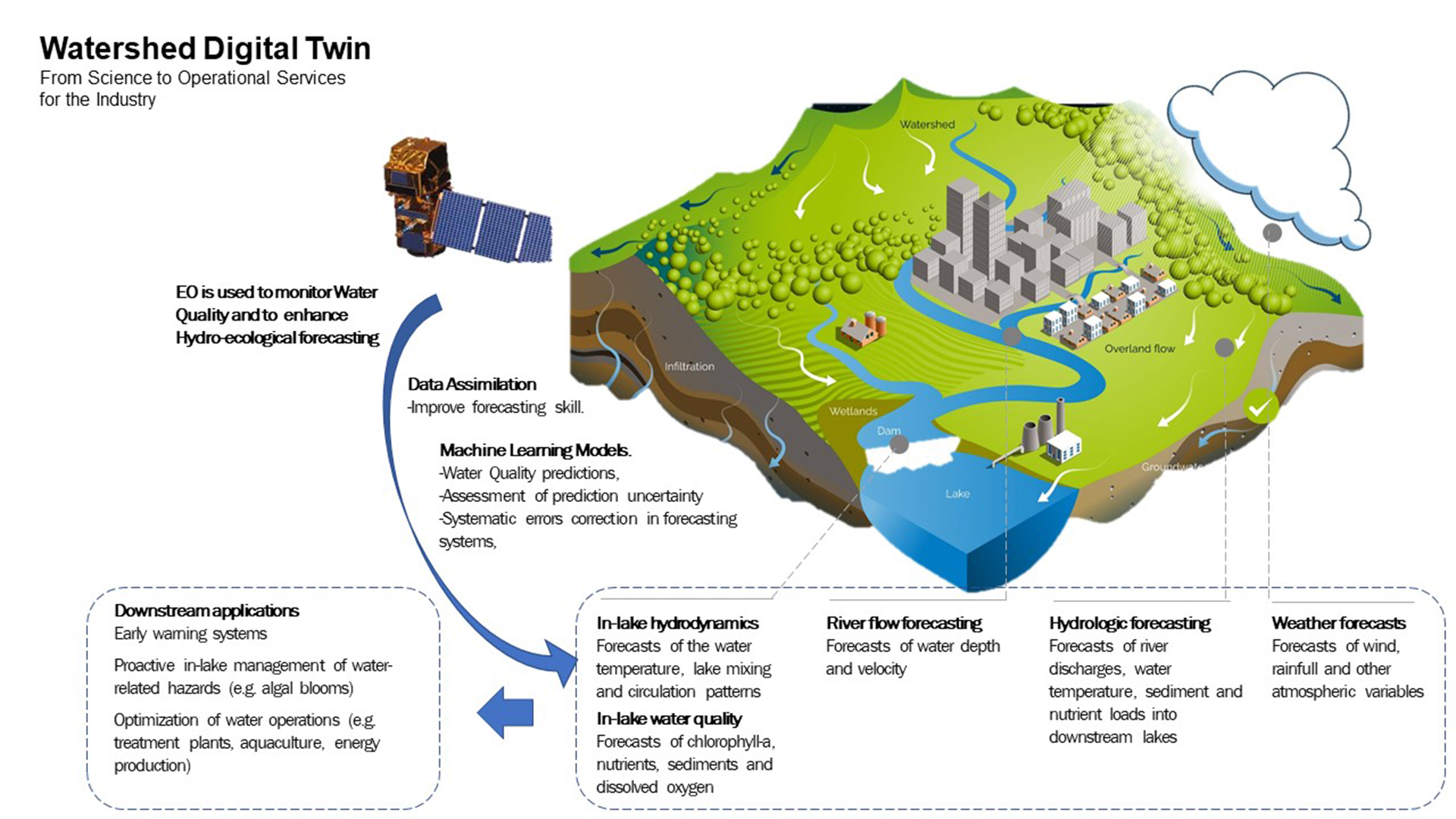
PrimeWater also has a strong cross-cutting scientific outreach that goes beyond the remote sensing domain, aspiring to add considerable value to the EO products, through advanced Environmental Modelling, Data Assimilation and Machine Learning techniques. Enhanced Earth observations, together with other data, are used for improving the capabilities of hydro-ecologic forecasting systems, generating actionable foresight in the water sector through the implementation of full-scale Watershed Digital Twins.
However, what makes the PrimeWater Project unique is the close connection our group establishes with the scientific community, as well as with stakeholders from various societal and economic domains that water is crosscutting, bringing new knowledge closer to end users. Several showcases across the globe demonstrate how advanced scientific workflows can be transformed into decision making services working together with the end-users in a co-development process:
- We have set up a Virtual Lab environment that will allow sharing of datasets, experimental protocols and methods in each scientific experiment, promoting collaborating research and enhancing the transparency and reproducibility of scientific results;
- We investigated and better understood the social and institutional determinants for innovation adoption in the water industry through behavioural analysis methods to enable stronger uptake of innovation;
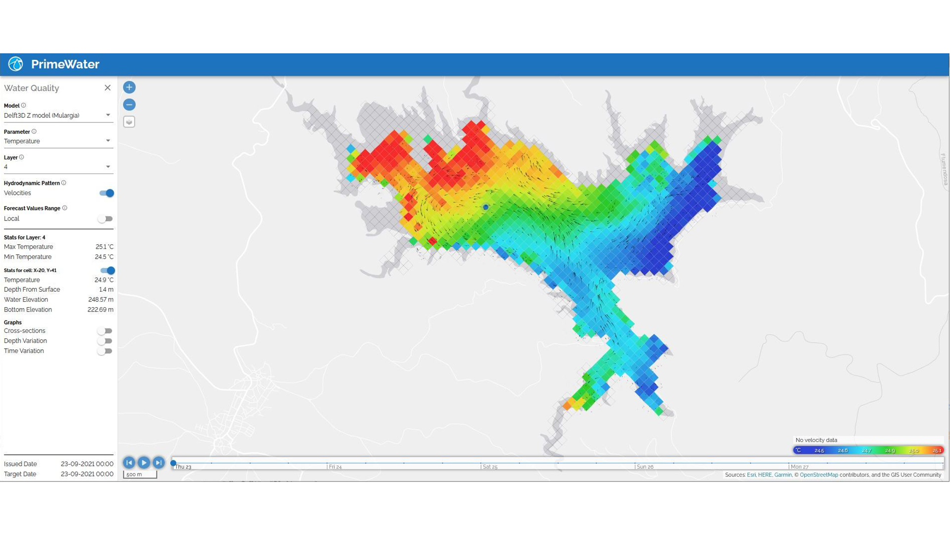
- We have developed an operational web-based platform (Water Quality Intelligence Suite – WQiS) to facilitate interoperability among EO and modelled services offering continuous monitoring of critical environmental parameters and producing forecasted water quality characteristics in reservoirs and lakes, to demonstrate the unique possibilities intelligent services can offer and establish confidence for potential users; and
- We are looking beyond the lifetime of the project and have created a Community of Practice (CoP) that will bring together end users, scientists and knowledge purveyors to ensure the continuous streamlining of science and innovation in the water sector.
We are hoping our initiative will stimulate wide interest to follow or join our work from the collaborative scientific experiments to the consultation and dissemination events that we are planning, establishing an active community around PrimeWater.
What is the Water Quality Intelligence Suite (WQiS) that was developed in the PrimeWater Project?
PrimeWater operational services automate scientific workflows, from satellite imagery to high reliability water forecasts for generating real time, short-to-medium range water quantity and quality forecasts for freshwater systems. The WQiS platform:
- Combines the data silos connecting proprietary data with near real-time, satellite-based water quality data and other remote sensing data and simplifies environmental reporting and hydro-ecological hazard risk assessments;
- Enables intelligent decision making by filling in water quality information gaps in time and space, increasing efficiency, saving costs and lowering operations risks;
- Transforms weather forecasts into river flows in the watershed and forecasts river discharges, water temperature, sediment and nutrient loads for up to ten days ahead;
- Generates hydro-ecological forecasts just like weather forecasts and provides key attributes for water quality in lakes and reservoirs to promote safety and drive efficiency ahead in time, so as to mitigate exposure to water-related hazards at an early stage; and
- Integrates forecasts into industry-specific downstream services.
How will these services help different water users interpret Earth observation information? What approaches are being used?
PrimeWater Services (Water Quality Intelligence Suite – WQiS) facilitates the water industry to identify hydro-ecological risks at an early stage and proact instead of react.
The PrimeWater Project aims at increasing the situational intelligence of water regulators, emergency planners, water-related industry professionals and local communities by introducing new EO and modelled data, extending actionable information in space and time.
When it comes to water operations, early detection and rapid response, as well as adaptive planning, are critical in proactively determining and mitigating water hazards since adapting to risks in a planned manner is far more efficient than reacting to a major system failure. At the same time, improved environmental performance is sought while lowering costs. Foresight, gained from modelling highly complex and dynamic systems and skilful predictive services can guide water professionals in making quick and data-informed decisions, achieving regulatory compliance at a low cost and improving the day-to-day performance.
 The project has received funding from the European Union’s Horizon H2020 Research and Innovation Programme under Grant Agreement No. 870497.
Please note, this article will also appear in the fifteenth edition of our quarterly publication.