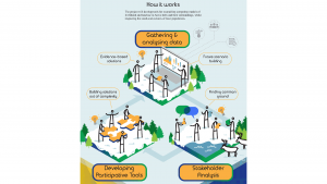
Developing participation tools for engaging local citizens, and facilitating their participation in land and sea use planning and conflict reconciliation.
Increasing global competition for natural resources poses major challenges to the Arctic.
The general aim of the ArcticHubs project is to explore ways to reconcile global industries with local livelihoods, as well as discover traditional and cultural ways of land use in the Arctic areas. As a part of this, the aim is to develop means for local citizens to participate in discussions and decision-making about land use in relation to different industries.
Development is made in selected areas, hubs which are important socioeconomic nodes representing various industries.
The advantages of Public Participation Geographic Information Systems
Geographic information systems-based participatory mapping methods such as Public Participation Geographic Information Systems (PPGIS), are increasingly used by decision-makers to improve the collection and utilisation of locally-relevant knowledge in decision-making and planning.
The development of tools, such as internet-based participatory mapping methods, enables the collection of localised information about citizens’ cultural and social views of their environments and important places, regardless of their physical presence in a certain place at a certain time. This helps to reach out to a bigger number of residents and right-holders, compared to in-person meetings or paper-based surveys.
The term ‘localised’ is important here, as it separates GIS-based methods from other surveys by allowing respondents to indicate on a map the places, areas, and other targets that are important for them in regard to different contexts.
About Maptionnaire
Maptionnaire is a PPGIS solution that gives a spatial dimension to experiences, habits, opinions, and wishes that participants submit through surveys made on this platform.
ArcticHubs is developing the Maptionnaire Community Engagement Platform. This is used as a data collection and conflict negotiation tool by the researchers, and also as a platform for communicating and sharing information with locals and stakeholders.
By leveraging Maptionnaire’s capabilities, ArcticHubs is helping to create a more collaborative environment; one where diverse voices are heard, and that enables the co-creation of solutions for land and sea resource management in the Arctic hubs.
Within the ArcticHubs project, Maptionnaire serves as a valuable tool to engage local citizens and facilitate their participation in generating additional layers of map content, describing current land and sea use, areas of conflict, possibilities, and solutions.
Its interactive map platform enables individuals to contribute their knowledge, perspectives, and ideas, thereby enriching the overall understanding of hub areas and fostering a sense of ownership in decisions made among the stakeholders of the project.
Besides this, Maptionnaire helps to analyse, collaborate, report, and communicate ongoing data collection.
Inari: Previous PPGIS surveys
One of the project hub areas is Inari in Finland. Inari is a picturesque municipality in northern Finland known for its natural beauty and rich cultural heritage.
In recent years, it has experienced a significant conflict over land use, notably with an increase in tourism development, reindeer herding, forestry, and hunting activities by non-locals. Many changes are impacting local and indigenous cultures and livelihoods.
In the case of Inari, two different PPGIS surveys have previously been carried out by the project: one about the effects of tourism, and another concerning the influence of different land uses on reindeer herding.
One of the main results of the PPGIS survey on tourism in Lake Inari was that it divides local opinions. Several different viewpoints on the use of the lake have been presented; some locals want to preserve it for the sake of nature conservation and indigenous Sámi culture.
Others wish for it to be used by the locals for leisure, fishing, and berry picking, for example. The idea of a new national park has also risen.
However, there are also those that want to develop tourism, including the municipality and some entrepreneurs.
Testing and developing PPGIS in Inari
Inari lake and its environment were selected as the arena for testing and developing more interactive PPGIS.
The reasons behind this were twofold; first of all, the new hotel plans have gained a lot of attention in various media.
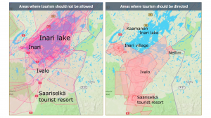
Secondly, the results of the Inari PPGIS tourism survey clearly highlighted Lake Inari as an area with opposing views of development (Fig.1). The development of the lake for tourism has been a particularly hot topic of discussion among the locals.
Therefore, it was decided to give the general public the opportunity to discuss the issue further and anonymously on a map-based platform.
The development of the community engagement platform kicked off in 2022. On the basis of the data collected and discussions with local stakeholders, the first meeting outlined a framework for the means of involving local people in a deeper dialogue about Lake Inari.
It was decided that more in-depth location-based discussion would be needed since the lake is large and could potentially host more overlapping activities.
Furthermore, it was decided that the discussion would be embedded on a website offering more information for the participants.
The development process of the community engagement platform has also involved the municipality of Inari and other stakeholders in commenting and developing the idea and content of the discussion page.
The officials of the municipality and the indigenous Sámi peoples’ representatives have pointed out that there is a need for this kind of platform, which could be also used in the municipality’s planning processes.
Launch of the community engagement platform
The community engagement platform was launched in June 2023, and it was announced on social media, in the local newspaper Inarilainen, and on the official sites of the municipality of Inari. Leaflets about the site were also put up on the walls of supermarkets in the Inari municipality.
The platform will be open for at least until the end of the autumn of 2023, and user experiences will be collected by feedback survey. Results of the survey will be used to develop the tool to better function as an online platform enabling community engagement in the co-creation of solutions for land and sea resource management in the Arctic hubs.
They will also be used as a communication tool for local policymakers and land use planners to inform local communities and stakeholders about the land use plans and coming projects, as well as to communicate co-produced solutions.
Findings serve as a valuable resource for policymakers, industry developers, and community members, guiding responsible tourism practices. By considering these insights, Inari and other Arctic hubs can continue to thrive as a destination, while maintaining their authenticity and protecting their cherished nature and heritage.
 This project has received funding from the European Union’s Horizon 2020 research and innovation programme under grant agreement No 869580.
Please note, this article will also appear in the sixteenth edition of our quarterly publication.