The Europlanet 2024 Research Infrastructure (RI) project looks at the many ways Machine Learning (ML) is revolutionising planetary science.
Traditionally, planetary science starts with a hypothesis. We test our theory experimentally, producing data. We analyse the data and, hopefully, the process results in new knowledge.
The advent of Machine Learning (ML) has enabled a new approach, known as data-driven science. Using the wealth of datasets and streams available, ML can explore the data to find a pattern or commonality. Out of these initial steps comes a hypothesis that can be tested through data analysis, which, again, hopefully leads to a new understanding. Clustering or fusing datasets, moreover, can reveal connections that are not recognisable in the individual datasets.
Our Solar System contains an exotic range of objects and environments ranging from vast gas giants, like Jupiter and Saturn, to the small rocky and icy bodies of asteroids and comets. Even the planets termed ‘terrestrial’ are a very mixed assortment, including the habitable Earth but also the hellishly hot Venus, scorched Mercury and cold, arid Mars. Over the past three decades, our knowledge of planetary systems has extended to those around other stars. These ‘exoplanetary’ systems have been found to contain strange objects not found in our solar system, such as lava planets, ocean worlds, and ‘hot-Jupiters’.
In recent years, data-driven planetary science has experienced exponential growth in the volumes of data available from diverse sources, including space missions, ground-based telescopes, computer modelling and laboratory and field experiments. To analyse the vast archives of data collected from all these sources, new methods and approaches are required. The introduction of ML tools and algorithms not only means that all the data can be investigated, but enables the combination and mining of data to find hidden correlations, detect anomalies, faults or missing information, and maximise the exploitation of data from planetary research to date.
Europlanet 2024 Research Infrastructure
The Europlanet 2024 Research Infrastructure is a €10m project, funded by the European Commission’s Horizon 2020 programme, that supports the planetary science community. The project’s core activities are to provide access to facilities, field sites, and data services.
However, Europlanet also provides investment through ‘Joint Research Activities’ that combine the expertise of multiple partners to create the new infrastructure and services needed to carry out world-leading planetary research. Since 2020, the project has developed ML tools to handle complex planetary science data more efficiently and provide opportunities to combine and visualise multiple diverse datasets. This programme has been further enhanced through a collaboration with a second Horizon 2020 project, EXPLORE, which is developing applications for the exploitation of galactic, stellar and lunar data, and provides a platform for deploying and testing ML tools and services.
Europlanet’s ML-powered tools are based on scientific cases proposed by the community that address key challenges in planetary research. From these proposals, seven cases were chosen to follow up initially during the project, and further cases have been added over time. All the tools are open-source, ready-to-use, and highly customisable, enabling other researchers to freely deploy and adapt them for their own research scenarios.
The ML-powered tools focus on three types of planetary science data: time-series data, where data mining can reveal the dynamical evolution of phenomena or time-dependent events; imagery, where training algorithms to recognise features can support automated mapping and classification of common characteristics; and other kinds of data, for example, spectral data, where characteristics like composition or surface ages can be identified.
Tools for time-dependent phenomena
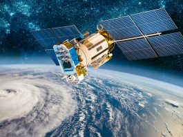
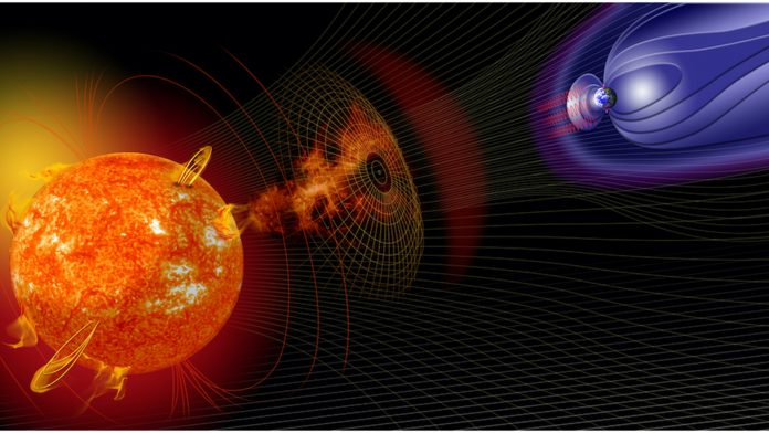
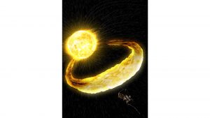
The Sun emits not only heat and light, but a stream of electrically charged particles. This ‘solar wind’ interacts with objects in its path and can potentially strip away planetary atmospheres. Earth, and other planets with a global magnetic field, are largely shielded from the effects of the solar wind. However, solar activity can result in flares, emission of solar energetic particles and eruptions of material, called coronal mass ejections, that can interact with Earth’s magnetic environment and, in severe cases, cause serious disruption to power grids, radio networks, and satellites.
Europlanet has developed a suite of ML tools to support investigations of the solar wind and its effects on planetary environments over time. One tool supports forecasting the severity of a solar storm based on its magnetic orientation compared to the Earth’s magnetic field. A second tool monitors the conditions controlling emissions by high-energy particles trapped in radiation belts. A third tool automatically identifies points in data streams when an orbiting spacecraft crosses over the boundary between a planet’s protective magnetic field and the unshielded conditions of the solar wind. Collectively, this deployment of ML enhances our understanding of solar wind interactions and our ability to protect infrastructure both here on Earth and on the surface of, or in orbit around, other planets.
Identifying hazards and resources
Every day, about 100 tonnes of rubble or dust from space enters the Earth’s atmosphere. Most of this burns up without being seen or reaching the ground. However, larger meteors can cause fireballs that streak across the sky and some fragments can reach the ground as meteorites. Increasingly, camera networks dedicated to fireball tracking are being installed around the world, both to facilitate meteorite recovery for research purposes and to increase our understanding of impacts to support planetary defence initiatives. Europlanet has been working with the professional and amateur meteoritic research community to develop ML-powered planetary science tools that extract information from imagery of fireballs to help determine their characteristics, trajectories, and potential origins.
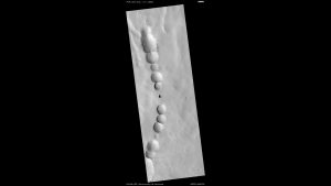
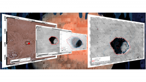
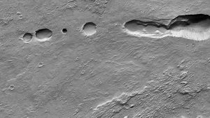
Across the Solar System, images of planetary surfaces exhibit many common features, such as pits, mounds, or craters. These features can reveal a wealth of information about the formation, history and potential useful resources of a planetary body. For example, ‘skylights’ or sinkholes on the Moon or Mars are of interest to geologists studying lava tubes and evidence of ancient volcanic activity.
However, skylights are also potential entrances to protected environments where underground habitats could be built for human explorers in the future. Craters can provide a detailed chronological record of the impact history of a planetary surface, potentially going back millions or billions of years, and may also trap water ice that could be used for life support and fuel. With a return of humans to the Moon planned within two to three years and international exploration strategies setting their sights on Mars, detailed and accurate mapping of surface features and resources at high resolution is essential.
ML and data-driven science tools created by Europlanet and EXPLORE enable the automatic identification and labelling of mounds, pits, craters and other surface features. This not only enhances the speed of mapping process but can also add layers of information, such as the size, depth, composition, and other characteristics of the features.
Tools for chemical characterisation
Many planetary science missions carry spectrometers to gather information on the mineralogy of planetary surfaces. Minerals reflect certain parts of the electromagnetic spectrum more strongly than others depending on their chemical composition.
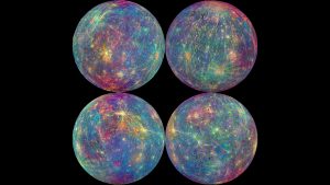
To support these spectral studies, a Europlanet ML algorithm has been trained with reflectance spectra generated in laboratory experiments at the visible and infrared wavelengths that are key to unlocking surface composition. An additional bespoke tool has been trained for unsupervised classification of infrared observations by NASA’s MESSENGER spacecraft, which orbited Mercury between 2011 and 2015. With ESA’s BepiColombo mission set to arrive at the solar system’s innermost planet in December 2025, this tool is helping BepiColombo’s spectrometer team to perform vital groundwork in identifying areas of particular interest and developing workflows for future analysis.
Impact on data-driven planetary science to date
As of July 2023, the development phase of Europlanet’s ML tools is largely complete and training and dissemination are underway to support their adoption by the community. The synergistic collaboration between Europlanet and EXPLORE has also demonstrated the EXPLORE platform’s usefulness to the planetary community in providing a test environment to deploy ML tools and other applications. The platform fills a previously unidentified gap in supporting the development of applications to the point of maturity needed for deployment on major data hubs, such as the European Open Science Cloud (EOSC) and ESA Datalabs.
Much of the development work for the ML tools has been performed by early career researchers, enabling them to build both their skills and experience and their professional profile within the scientific community.
Overall, by developing ML tools tailored to data-driven planetary science, Europlanet has cemented collaborations, started to build new user communities and developed services that are already resulting in publications. While the planetary science community could be seen as late to the party in adopting ML, interest is now high. This couldn’t be more timely – with flagship missions to Mercury and Jupiter soon adding to the deluge of data streams, the era of data-driven science is only just beginning.
Europlanet 2024 RI and EXPLORE have received funding from the European Union’s Horizon 2020 research and innovation programme under grant agreements No. 871149 and No. 101004214, respectively.
Please note, this article will also appear in the fifteenth edition of our quarterly publication.