A research team from the Alfred Wegner Institute, Helmholtz Centre for Polar and Marine Research (AWI), discovered that the formation of the West Antarctic ice sheet, up to 35 million years ago, may have been slower than previously believed.
Roughly 35 million years ago, Earth cooled rapidly. At roughly the same time, the Drake Passage formed between South America and the Antarctic, paving the way for the Antarctic Circumpolar Current.
Due to these factors, Antarctica was completely covered in ice at a rapid speed. A study from the Alfred Wegener Institute now shows that this massive glaciation was delayed in at least one region. This is enlightening information concerning the early history of the West Antarctic Ice Sheet that could help to predict its unstable future.
The study was just published in the Nature journal Communications Earth & Environment.
What have scientists discovered when researching the West Antarctic?
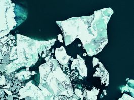
The West Antarctic has been in the spotlight for years for climate researchers. This is because the West Antarctic Ice Sheet lying atop the continent, stretches to the adjacent Amundsen Sea, and near the coast, the ice is still in direct contact with the soil; farther toward the open sea where it floats. Because climate change progressively warms the seawater, the latter is increasingly eroding the ice shelf from below.
The grounding line, which is the last point at which the ice still rests on the ground, moves farther and farther inland. Due to meltwater and calving icebergs, the Thwaites Glacier, which flows into the Amundsen Sea, now loses twice as much ice as 30 years ago. If the West Antarctic Ice Sheet were to collapse entirely, global sea levels would rise by more than three metres.
“The stability of the West Antarctic Ice Sheet is critical to the future development of the global sea level,” explained Gabriele Uenzelmann-Neben lead author from the AWI. “Accordingly, researchers around the world are working to predict the future behaviour of the ice in a warmer world using numerical simulation.
“The more we know about the history of the West Antarctic Ice Sheet, the more accurate we can make these models. Its more recent history is well-documented, but we still know very little about its earlier years – particularly the formation phase. Our study delivers an important piece of the puzzle.”
How did researchers gather this novel information in this study?
In the course of two research cruises on board the Polarstern, the Geophysicist and her team investigated sediments in the vicinity of Pine Island Trough, a channel-like furrow in the seafloor of the shallow part of the Amundsen Sea, which stretches from north to south and leads directly toward the western coast of Antarctica.
To collect data, the AWI team relied on the tried and proven reflection seismology method: the Polarstern towed a 3,000-metre-long measuring cable behind her. The cable is equipped with hydrophones that utilise a total of 240 measuring channels. During survey cruises, an airgun is used to produce seismic pulses behind the ship.
These pulses penetrate the seafloor and are reflected back at geological boundaries – between the sediment and hard rock, for example – which is recorded by the streamer’s hydrophones. Based on the different travel times for the waves and the respective positions of the individual channels, the internal structure of the seafloor can be mapped by researchers.
What did the research reveal?
The measurement data revealed a large sediment body, a sediment drift, on the eastern flank of Pine Island Trough, one with no counterpart on its western side.
Uenzelmann-Neben noted: “Because of the Coriolis effect produced by Earth’s rotation, this asymmetrical deposition of a sediment drift on the trough’s eastern side but not the western one can only have been produced by a deep-water current that flowed toward the coast from north to south.
“In order for that to occur, the ocean circulation at the time of the deposition had to be similar to today’s conditions, that is, the prevailing westerlies and the Antarctic Circumpolar Current had to have been located far to the south. And similar to today, the deep water upwelled through the trough must have been comparatively warm.”
An additional study of pollen from the sediment cores gathered near the trough indicated that the base of the sediment drift was formed roughly 34- 36 million years ago. At precisely the same time – the Eocene-Oligocene boundary – temperatures plummeted around the globe, and the Antarctic continent became covered in ice.
AWI geophysicists concluded: “Our study offers compelling evidence that at the time of the great glaciation, warmer deep water upwelled near the Amundsen Sea shelf and delayed the West Antarctic Ice Sheet’s expansion to the sea.
“This important and unexpected finding emphasises the tremendous importance that ocean currents had even during the formation phase of the West Antarctic Ice Sheet and continue to have today. Armed with this additional knowledge concerning the ice sheet’s earliest phase, forecasts on its future stability and ice retreat can now be improved.”