
International Editor Clifford Holt spoke with the European Space Agency’s Sentinel-1 and SMOS teams about how the Copernicus programme and Earth Explorer missions provide information to both forecast and respond to disasters such as floods and earthquakes
Copernicus is the most ambitious Earth Observation programme to date. It is a cornerstone of Europe’s efforts to monitor the planet and its many ecosystems. Providing an overview of the programme, Ramón Torres Cuesta, Project Manager of the Sentinel-1 Project, told The Innovation Platform: “The Copernicus programme is based on a partnership between the European Union, ESA, and the Member States. It is designed to ensure the continuous provision of reliable data and information on environment- and security-related services, primarily to users responsible for making, implementing, and monitoring the relevant policies in the EU and its Member States. Thus, Copernicus is a user-driven programme.”
The Copernicus services comprise operational mapping, monitoring, and forecasting activities for land, marine, atmosphere, emergency, security, and climate change, and while the European Commission leads the programme, it is implemented in partnership with the European Space Agency (ESA). “The Commission, acting on behalf of the European Union, is responsible for the overall initiative, setting user requirements and managing the services. ESA acts as the system architect for the Copernicus Space Component (CSC) and co-ordinates its development,” Cuesta explained.
As part of the Copernicus Space Component, the Sentinel-1 mission is implemented through a pair of identical C-band Synthetic Aperture Radar (SAR) satellites comprising the current A and B units (that is, Sentinel-1A and B). Sentinel-1A was successfully launched on 3 April 2014, followed by the successful launch of Sentinel-1B on 25 April 2016.
According to Cuesta, “the Copernicus programme’s long-term continuity is ensured by Sentinel-1C and D, which are currently under development. The launch of Sentinel-1C is foreseen for the end of 2022, while Sentinel-1D will go into storage for an envisaged launch in 2024.”
SAR data and information products
The Sentinel-1 mission has been specifically designed to systematically acquire and routinely provide SAR data and information products for the Copernicus ocean, land, emergency, and climate change services, as well as to national user services. Because of its SAR instrument, the Sentinel-1 mission provides day/night and all-weather imaging capabilities of the Earth’s surface. “In particular,” Cuesta outlined, “the Sentinel-1 mission supports applications in areas such as the observation of the marine environment, including oil spill detection and Arctic/Antarctic sea-ice monitoring, as well as the surveillance of maritime transport zones (such as the European and North Atlantic zones). In addition, it enables the mapping of land surfaces including vegetation cover (such as forest cover) and in support of crisis situations, such as natural disasters (including flooding and earthquakes), and humanitarian aid.
“Sentinel-1A and Sentinel-1B fly in a near polar, sun-synchronised (dawn-dusk) orbit at an altitude of 693km and in the same orbital plane with 180° phased positions. The 12-day orbital repeat cycle of each satellite – six days for the entire Sentinel-1 constellation – along with the use of pre-programmed SAR mode operations provides a high revisit frequency and systematic global SAR image coverage. This systematic data acquisition enables the build-up of long data time series, supporting applications such as soil moisture retrieval and snow cover mapping, amongst others.”
In addition to the systematic coverage and high revisit frequency, the Sentinel-1 mission has also set a benchmark for achieving a high-quality end-to-end SAR performance, namely the stable and high radiometric and geolocation accuracy. Furthermore, Cuesta explained that “ due to the short repeat orbit interval along with a tight orbit control, the Sentinel-1 mission enables repeat-pass, cross-SAR interferometry (InSAR) applications, such as the mapping of surface deformation, caused, for example, by tectonic processes, volcanic activities, landslides, or ground subsidence, as well as the monitoring of cryosphere dynamics (e.g. glacier flow).”
The Sentinel-1 SAR instrument supports four exclusive imaging modes providing different resolution and coverage: Interferometric Wide Swath (IW), Extra Wide Swath (EW), Stripmap (SM), and Wave (WV). Cuesta said: “Both the IW and EW imaging modes operate in the novel TOPS mode (Terrain Observation with Progressive Scans), providing a large swath width of 250km and 400km at a ground resolution of 5mx20m and 20mx40m, respectively. In fact, the Interferometric Wide Swath (IW) mode is the main mode of operations for the systematic data acquisition over land and coastal areas. The Extra Wide Swath (EW) mode is mainly used for sea-ice mapping and oil spill monitoring, while the Wave (WV) mode is used for data acquisitions over open ocean. The Stripmap (SM) mode, with a swath width of 80km at a ground resolution of 5mx5m, is used to map small islands and volcanoes.”
The free and open data policy is a key element to boost the use of the Copernicus data in general.
“In particular,” Cuesta concluded, “the systematic and conflict-free acquisition concept of the Sentinel-1 mission satisfies the needs of most Sentinel-1data users. This is reflected in the large number of registered users, which is an order of magnitude larger than for any previous SAR mission.”
The Copernicus Emergency Management Service (CEMS)
The Copernicus Emergency Management Service (EMS) provides information for emergency response for different natural and man-made disasters and other humanitarian disasters as well as prevention, preparedness, response, and recovery activities.
The Copernicus EMS is composed of:
- An on-demand mapping component including the provision of rapid maps for emergency response and risk and recovery maps for prevention and planning; and
- The early warning and monitoring component, which includes systems for floods ,i.e. the European Flood Awareness System (EFAS) and Global Flood Awareness System (GloFAS), droughts (European Drought Observatory – Global Drought Observatory), and forest fires (European Forest Fire Information System – Global Wildfire Information System).
Rapid mapping provides geospatial information within hours or days of a service request in order to support emergency management activities in the immediate aftermath of a disaster. Risk and Recovery Mapping supplies geospatial information in support of disaster management activities including prevention, preparedness, risk reduction, and recovery phases.
SENTINEL-1 – analysing earthquakes
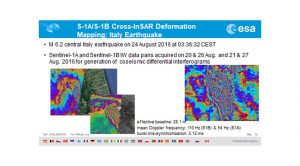
The Sentinel-1 repeat orbit interval of six days for the constellation, along with small orbital baselines enables the implementation of cross-SAR interferometry (InSAR) by combining data acquired by Sentinel-1A and B from repeat-pass orbits. This supports geophysical applications, such as the monitoring of cryosphere dynamics (such as glacier flow) and the mapping of surface deformation, caused, for example, by tectonic processes, volcanic activities, landslides, or ground subsidence.
In general, Sentinel-1A and Sentinel-1B data, acquired shortly before and after an earthquake, respectively, can be combined, along with using terrain height information, e.g. a Digital Elevation Model (DEM), to measure coseismic surface displacements, such as ground motion, which occurs between the two acquisition dates due to tectonics. This leads to the colourful interference (i.e. fringe) pattern known as ‘interferogram’, which enables scientists to quantify the vertical and horizontal surface displacement with an accuracy in the order of a few millimetres.
The possibility to generate Sentinel-1 A&B cross-interferograms is mainly due to the stable radar pointing on both spacecraft and the highly accurate time synchronization between corresponding the IW mode (TOPS) images, acquired independently by both SAR instruments.
In fact, this IW mode-based cross-InSAR capability is considered an important benchmark for the overall mission performance as it allows an instantaneous, and therefore efficient, mapping of wide-area surface deformation, e.g. coseismic surface displacements, with an accuracy that is in the order of a few millimetres.
This innovative, wide-area cross-InSAR mapping capability was first demonstrated for the mapping of the central Italy earthquake that occurred on 24 August 2016, using Sentinel-1A and B IW images acquired a few weeks after the launch of Sentinel-1B.
Floods
The European Flood Awareness Systems (EFAS) and Global Flood Awareness Systems (GloFAS) provide complementary flood forecast information to relevant stakeholders that support flood risk management at the national, regional, and global level.
The Global Flood Awareness System (GloFAS), jointly developed by the European Commission and the European Centre for Medium-Range Weather Forecasts (ECMWF), is a global hydrological forecast and monitoring system independent of administrative and political boundaries. It couples state-of-the art weather forecasts with a hydrological model and with its continental scale set-up provides downstream countries with information on upstream river conditions as well as continental and global overviews. GloFAS produces daily flood forecasts (since 2011) and monthly seasonal streamflow outlooks (since November 2017).
As an example, in 2019, forecasts from the Copernicus Emergency Management Service’s Global Flood Awareness System (GloFAS) were used to provide real-time emergency flood forecast bulletins to support international humanitarian decision-making ahead of and during two devastating tropical cyclones in Mozambique.
EFAS aims to support preparatory measures before major flood events strike, particularly in the large trans-national river basins and throughout Europe in general. EFAS is the first operational European system monitoring and forecasting floods across Europe. It provides complementary, added-value information (e.g. probabilistic, medium-range flood forecasts, flash flood indicators or impact forecasts) to the relevant national and regional authorities. Furthermore, EFAS keeps the Emergency Response Coordination Centre (ERCC) informed about ongoing and possibly upcoming flood events across Europe.
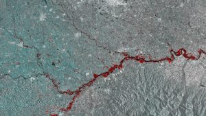
The Sentinel-1 mission is fundamental regarding both the on-demand mapping and the early warning and monitoring component of CEMS. Without the data of Sentinel-1, CEMS would not be able to achieve the same level of service as it has now or develop new products, such as the new global flood-monitoring product.
For flood monitoring, Sentinel-1 SAR is absolutely crucial as it is independent from daylight and cloud cover, the latter being crucial as in most cases at the beginning of the flooding there is always a high cloud cover.
The Synthetic Aperture Radar (SAR) instrument and flood monitoring
Sentinel-1 offers a high revisit frequency, high spatial resolution, excellent radiometric image quality, and fast access to the satellite images in real time or within a few hours after sensing. “Therefore,” Dirk Geudtner, Sentinel-1 System Manager, “Sentinel-1 data are almost exclusively used for rapid mapping, i.e. the detection of flooded areas (this accounted for 16 out of 20 activations during the period April 2019 to February 2020) and for risk and recovery mapping (accounting for 57% of all activations during the period April 2019 to April 2020). In particular, the Sentinel-1 data are used for flood delineation, temporal analysis of flood events, and damage assessment.”
Furthermore, Sentinel-1 enables, for the first time, the implementation of a continuous, fully automatic flood monitoring system. This system significantly benefits flood risk management worldwide as it provides information on practically all ongoing major floods globally, as well as creating an archive of flood events, which is highly valuable for the evaluation of flood impacts.
SMOS – forecasting floods and droughts
The Soil Moisture and Ocean Salinity (SMOS) satellite mission is ESA’s second Earth Explorer. Earth Explorers are ESA’s innovation flagships, exploring novel sensor technologies and addressing science questions that have so far been uncharted in Earth Observation.
SMOS and BIOMASS Mission Manager, Klaus Scipal, explained that “SMOS is an L-band radiometer (passive), which measures the brightness temperature of areas on the Earth’s surface using a novel interferometric signal processing technique. The main objective of SMOS is to measure soil moisture (the water content in the top-most layer of the soil) and ocean salinity. Due to the use of microwave technology, it is able to measure during both the day and night, as well as under cloud cover conditions. Due to its wide swath, it can frequently provide observations of the entire globe. This is particularly important for flood forecasting, which involves rapidly evolving systems. In addition, SMOS has a near real-time observing capacity (i.e. observations are available within three hours of sensing) which allows the assimilation of the observation in operational forecasting systems.”
The signal measured is sensitive to the soil moisture within the top few centimetres of the soil layer. The moisture content of the soil is a main driver for floods as the soil acts as a major water reservoir and buffer for access precipitation. “The information about the soil moisture is an important parameter for operational forecast systems, such as the one run by ECMWF, for floods and droughts,” Scipal explained. “SMOS products are routinely assimilated in the ECMWF weather forecast system and, as such, make ECMWF’s weather forecasts more precise every day. Recent research results indicate that the greatest impact of SMOS’s soil moisture products was on high flows and flood peaks, which coincide with areas having open land cover (i.e. sparse vegetation).”
Ramón Torres Cuesta
Sentinel-1 Project Manager
Dirk Geudtner
Sentinel-1 System Manager
Klaus Scipal
SMOS and BIOMASS Mission Manager
Tweet @esa
Tweet @CopernicusEU
Tweet @esa_smos
www.esa.int/Applications/Observing_the_Earth/Copernicus/Sentinel-1
www.esa.int/Applications/Observing_the_Earth/SMOS
Please note, this article will also appear in the fourth edition of our new quarterly publication.


